You are here: Home > Network List > TA - USArray Transportable Network (new EarthScope stations) Stations List
> Station Z41A Richland Creek Farm, El Dorado, AR, USA > Earthquake Result Viewer
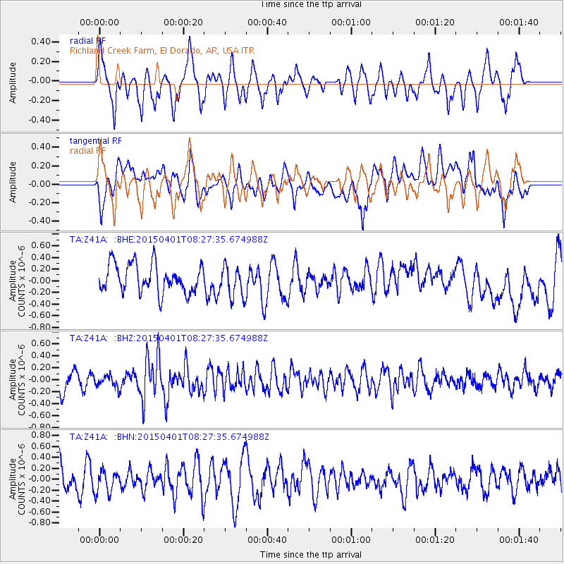
Z41A Richland Creek Farm, El Dorado, AR, USA - Earthquake Result Viewer
*The percent match for this event was below the threshold and hence no stack was calculated.
| Earthquake location: |
Near Coast Of Central Chile |
| Earthquake latitude/longitude: |
-29.3/-71.8 |
| Earthquake time(UTC): |
2015/04/01 (091) 08:17:26 GMT |
| Earthquake Depth: |
21 km |
| Earthquake Magnitude: |
5.5 MB |
| Earthquake Catalog/Contributor: |
NEIC PDE/NEIC ALERT |
|
| Network: |
TA USArray Transportable Network (new EarthScope stations) |
| Station: |
Z41A Richland Creek Farm, El Dorado, AR, USA |
| Lat/Lon: |
33.26 N/92.80 W |
| Elevation: |
62 m |
|
| Distance: |
65.3 deg |
| Az: |
340.707 deg |
| Baz: |
159.858 deg |
| Ray Param: |
$rayparam |
*The percent match for this event was below the threshold and hence was not used in the summary stack. |
|
| Radial Match: |
55.934013 % |
| Radial Bump: |
384 |
| Transverse Match: |
44.56275 % |
| Transverse Bump: |
400 |
| SOD ConfigId: |
7422571 |
| Insert Time: |
2019-04-18 00:57:42.425 +0000 |
| GWidth: |
2.5 |
| Max Bumps: |
400 |
| Tol: |
0.001 |
|
Signal To Noise
| Channel | StoN | STA | LTA |
| TA:Z41A: :BHZ:20150401T08:27:35.674988Z | 0.6429985 | 9.956206E-8 | 1.5484027E-7 |
| TA:Z41A: :BHN:20150401T08:27:35.674988Z | 0.71195954 | 2.0780368E-7 | 2.918757E-7 |
| TA:Z41A: :BHE:20150401T08:27:35.674988Z | 1.1879351 | 2.8789137E-7 | 2.4234606E-7 |
| Arrivals |
| Ps | |
| PpPs | |
| PsPs/PpSs | |


