You are here: Home > Network List > AV - Alaska Volcano Observatory Stations List
> Station SPCR Ckakachatna River, Mount Spurr, Alaska > Earthquake Result Viewer
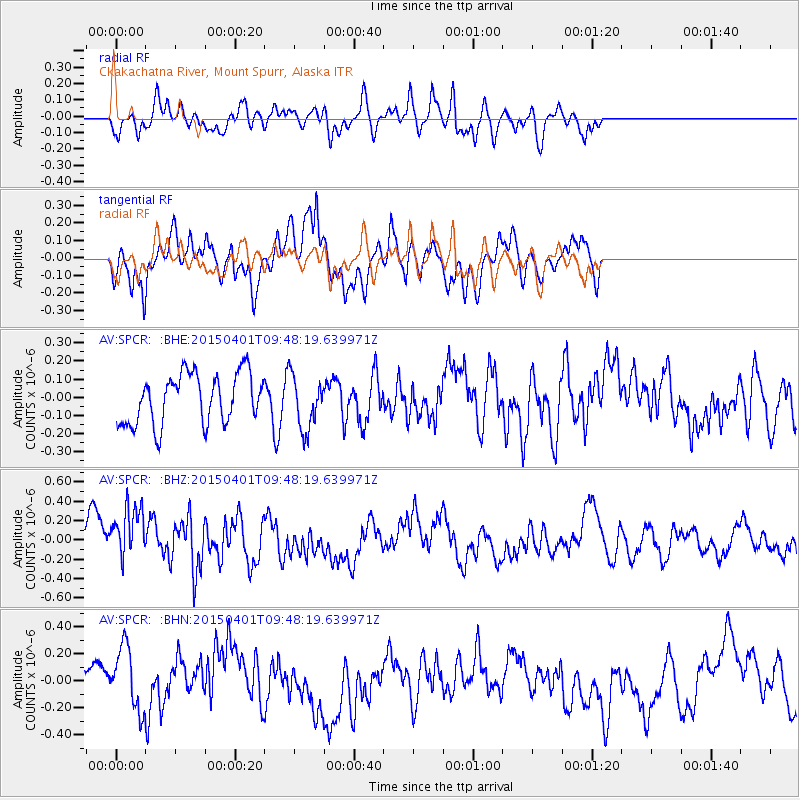
SPCR Ckakachatna River, Mount Spurr, Alaska - Earthquake Result Viewer
*The percent match for this event was below the threshold and hence no stack was calculated.
| Earthquake location: |
Tanimbar Islands Reg., Indonesia |
| Earthquake latitude/longitude: |
-6.9/132.5 |
| Earthquake time(UTC): |
2015/04/01 (091) 09:35:58 GMT |
| Earthquake Depth: |
24 km |
| Earthquake Magnitude: |
5.8 MB |
| Earthquake Catalog/Contributor: |
NEIC PDE/NEIC COMCAT |
|
| Network: |
AV Alaska Volcano Observatory |
| Station: |
SPCR Ckakachatna River, Mount Spurr, Alaska |
| Lat/Lon: |
61.20 N/152.21 W |
| Elevation: |
984 m |
|
| Distance: |
89.0 deg |
| Az: |
27.934 deg |
| Baz: |
253.827 deg |
| Ray Param: |
$rayparam |
*The percent match for this event was below the threshold and hence was not used in the summary stack. |
|
| Radial Match: |
68.86377 % |
| Radial Bump: |
400 |
| Transverse Match: |
65.631134 % |
| Transverse Bump: |
400 |
| SOD ConfigId: |
7422571 |
| Insert Time: |
2019-04-18 01:00:40.374 +0000 |
| GWidth: |
2.5 |
| Max Bumps: |
400 |
| Tol: |
0.001 |
|
Signal To Noise
| Channel | StoN | STA | LTA |
| AV:SPCR: :BHZ:20150401T09:48:19.639971Z | 1.5379672 | 3.1606157E-7 | 2.0550605E-7 |
| AV:SPCR: :BHN:20150401T09:48:19.639971Z | 1.5597254 | 2.3701409E-7 | 1.5195886E-7 |
| AV:SPCR: :BHE:20150401T09:48:19.639971Z | 1.0112034 | 1.3865339E-7 | 1.371172E-7 |
| Arrivals |
| Ps | |
| PpPs | |
| PsPs/PpSs | |


