You are here: Home > Network List > KN - Kyrgyz Seismic Telemetry Network Stations List
> Station CHM KN.CHM > Earthquake Result Viewer
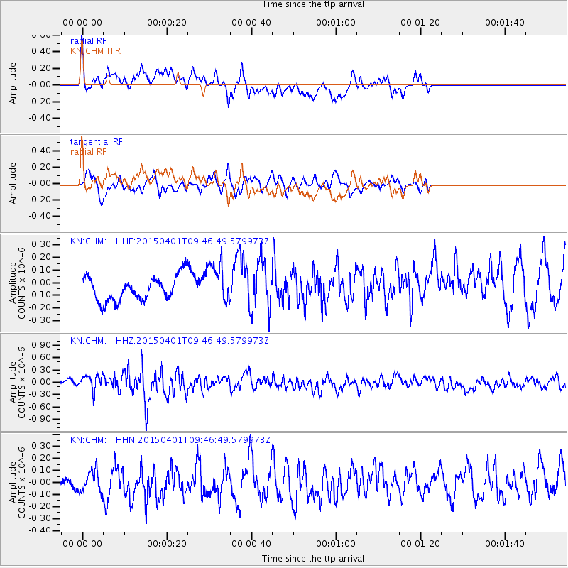
CHM KN.CHM - Earthquake Result Viewer
*The percent match for this event was below the threshold and hence no stack was calculated.
| Earthquake location: |
Tanimbar Islands Reg., Indonesia |
| Earthquake latitude/longitude: |
-6.9/132.5 |
| Earthquake time(UTC): |
2015/04/01 (091) 09:35:58 GMT |
| Earthquake Depth: |
24 km |
| Earthquake Magnitude: |
5.8 MB |
| Earthquake Catalog/Contributor: |
NEIC PDE/NEIC COMCAT |
|
| Network: |
KN Kyrgyz Seismic Telemetry Network |
| Station: |
CHM KN.CHM |
| Lat/Lon: |
43.00 N/74.75 E |
| Elevation: |
655 m |
|
| Distance: |
72.1 deg |
| Az: |
319.313 deg |
| Baz: |
118.093 deg |
| Ray Param: |
$rayparam |
*The percent match for this event was below the threshold and hence was not used in the summary stack. |
|
| Radial Match: |
71.40416 % |
| Radial Bump: |
400 |
| Transverse Match: |
56.910137 % |
| Transverse Bump: |
355 |
| SOD ConfigId: |
7422571 |
| Insert Time: |
2019-04-18 01:01:12.886 +0000 |
| GWidth: |
2.5 |
| Max Bumps: |
400 |
| Tol: |
0.001 |
|
Signal To Noise
| Channel | StoN | STA | LTA |
| KN:CHM: :HHZ:20150401T09:46:49.579973Z | 2.0820832 | 2.0201668E-7 | 9.702622E-8 |
| KN:CHM: :HHN:20150401T09:46:49.579973Z | 1.418327 | 9.1019224E-8 | 6.4173655E-8 |
| KN:CHM: :HHE:20150401T09:46:49.579973Z | 1.6256974 | 1.5830022E-7 | 9.7373736E-8 |
| Arrivals |
| Ps | |
| PpPs | |
| PsPs/PpSs | |


