You are here: Home > Network List > KN - Kyrgyz Seismic Telemetry Network Stations List
> Station TKM2 - > Earthquake Result Viewer
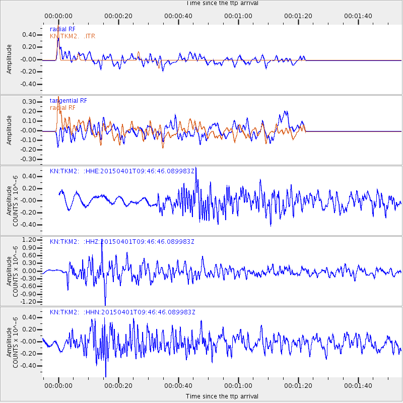
TKM2 - - Earthquake Result Viewer
*The percent match for this event was below the threshold and hence no stack was calculated.
| Earthquake location: |
Tanimbar Islands Reg., Indonesia |
| Earthquake latitude/longitude: |
-6.9/132.5 |
| Earthquake time(UTC): |
2015/04/01 (091) 09:35:58 GMT |
| Earthquake Depth: |
24 km |
| Earthquake Magnitude: |
5.8 MB |
| Earthquake Catalog/Contributor: |
NEIC PDE/NEIC COMCAT |
|
| Network: |
KN Kyrgyz Seismic Telemetry Network |
| Station: |
TKM2 - |
| Lat/Lon: |
42.92 N/75.60 E |
| Elevation: |
2020 m |
|
| Distance: |
71.5 deg |
| Az: |
319.552 deg |
| Baz: |
118.741 deg |
| Ray Param: |
$rayparam |
*The percent match for this event was below the threshold and hence was not used in the summary stack. |
|
| Radial Match: |
68.5509 % |
| Radial Bump: |
400 |
| Transverse Match: |
69.162766 % |
| Transverse Bump: |
400 |
| SOD ConfigId: |
7422571 |
| Insert Time: |
2019-04-18 01:01:15.143 +0000 |
| GWidth: |
2.5 |
| Max Bumps: |
400 |
| Tol: |
0.001 |
|
Signal To Noise
| Channel | StoN | STA | LTA |
| KN:TKM2: :HHZ:20150401T09:46:46.089983Z | 2.0779972 | 2.0405537E-7 | 9.819809E-8 |
| KN:TKM2: :HHN:20150401T09:46:46.089983Z | 1.0881305 | 9.847688E-8 | 9.050098E-8 |
| KN:TKM2: :HHE:20150401T09:46:46.089983Z | 1.3816277 | 1.0404466E-7 | 7.5305856E-8 |
| Arrivals |
| Ps | |
| PpPs | |
| PsPs/PpSs | |


