You are here: Home > Network List > CO - South Carolina Seismic Network Stations List
> Station PAULI Pauline, SC, USA > Earthquake Result Viewer
PAULI Pauline, SC, USA - Earthquake Result Viewer
| Earthquake location: |
Southeastern Alaska |
| Earthquake latitude/longitude: |
60.4/-140.3 |
| Earthquake time(UTC): |
2014/07/17 (198) 11:49:32 GMT |
| Earthquake Depth: |
0.6 km |
| Earthquake Magnitude: |
5.8 MI |
| Earthquake Catalog/Contributor: |
NEIC PDE/NEIC ALERT |
|
| Network: |
CO South Carolina Seismic Network |
| Station: |
PAULI Pauline, SC, USA |
| Lat/Lon: |
34.82 N/81.81 W |
| Elevation: |
179 m |
|
| Distance: |
45.0 deg |
| Az: |
97.333 deg |
| Baz: |
323.204 deg |
| Ray Param: |
0.0715712 |
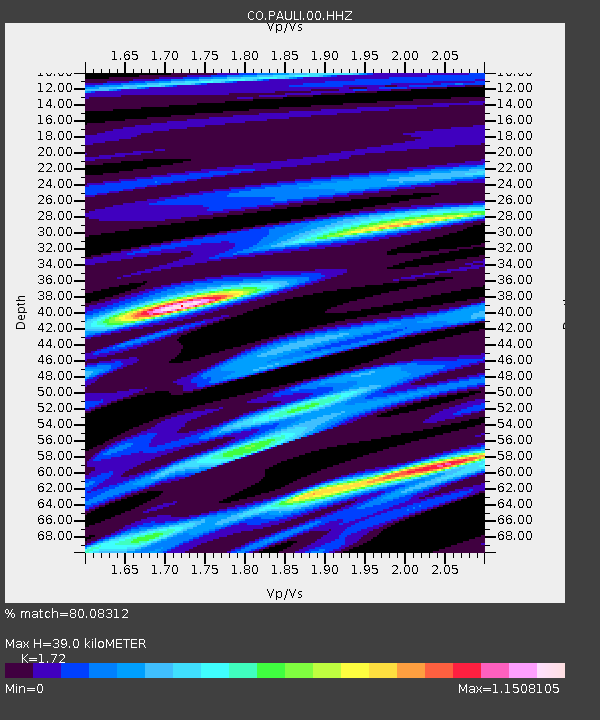
| Estimated Moho Depth: |
39.0 km |
| Estimated Crust Vp/Vs: |
1.72 |
| Assumed Crust Vp: |
6.419 km/s |
| Estimated Crust Vs: |
3.732 km/s |
| Estimated Crust Poisson's Ratio: |
0.24 |
|
| Radial Match: |
80.08312 % |
| Radial Bump: |
400 |
| Transverse Match: |
46.57385 % |
| Transverse Bump: |
400 |
| SOD ConfigId: |
751272 |
| Insert Time: |
2014-07-31 12:09:19.007 +0000 |
| GWidth: |
2.5 |
| Max Bumps: |
400 |
| Tol: |
0.001 |
|

Signal To Noise
| Channel | StoN | STA | LTA |
| CO:PAULI:00:HHZ:20140717T11:57:18.279999Z | 3.680427 | 5.061862E-7 | 1.3753464E-7 |
| CO:PAULI:00:HHN:20140717T11:57:18.279999Z | 2.6860044 | 2.5649013E-7 | 9.549133E-8 |
| CO:PAULI:00:HHE:20140717T11:57:18.279999Z | 2.2408502 | 1.608805E-7 | 7.17944E-8 |
| Arrivals |
| Ps | 4.7 SECOND |
| PpPs | 15 SECOND |
| PsPs/PpSs | 20 SECOND |


