You are here: Home > Network List > GS - US Geological Survey Networks Stations List
> Station OK029 Liberty Lake, Oklahoma, USA > Earthquake Result Viewer
OK029 Liberty Lake, Oklahoma, USA - Earthquake Result Viewer
| Earthquake location: |
Southeastern Alaska |
| Earthquake latitude/longitude: |
60.4/-140.3 |
| Earthquake time(UTC): |
2014/07/17 (198) 11:49:32 GMT |
| Earthquake Depth: |
0.6 km |
| Earthquake Magnitude: |
5.8 MI |
| Earthquake Catalog/Contributor: |
NEIC PDE/NEIC ALERT |
|
| Network: |
GS US Geological Survey Networks |
| Station: |
OK029 Liberty Lake, Oklahoma, USA |
| Lat/Lon: |
35.80 N/97.45 W |
| Elevation: |
333 m |
|
| Distance: |
36.7 deg |
| Az: |
112.357 deg |
| Baz: |
325.582 deg |
| Ray Param: |
0.07653591 |
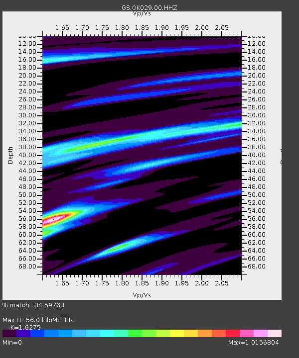
| Estimated Moho Depth: |
56.0 km |
| Estimated Crust Vp/Vs: |
1.63 |
| Assumed Crust Vp: |
6.426 km/s |
| Estimated Crust Vs: |
3.948 km/s |
| Estimated Crust Poisson's Ratio: |
0.20 |
|
| Radial Match: |
84.59768 % |
| Radial Bump: |
277 |
| Transverse Match: |
57.674538 % |
| Transverse Bump: |
400 |
| SOD ConfigId: |
751272 |
| Insert Time: |
2014-07-31 12:12:05.891 +0000 |
| GWidth: |
2.5 |
| Max Bumps: |
400 |
| Tol: |
0.001 |
|

Signal To Noise
| Channel | StoN | STA | LTA |
| GS:OK029:00:HHZ:20140717T11:56:10.065002Z | 14.846399 | 1.1969993E-6 | 8.062556E-8 |
| GS:OK029:00:HH1:20140717T11:56:10.065002Z | 4.3654633 | 4.4814644E-7 | 1.02657246E-7 |
| GS:OK029:00:HH2:20140717T11:56:10.065002Z | 4.939894 | 3.6266607E-7 | 7.3415755E-8 |
| Arrivals |
| Ps | 5.9 SECOND |
| PpPs | 21 SECOND |
| PsPs/PpSs | 27 SECOND |


