You are here: Home > Network List > N4 - Central and EAstern US Network Stations List
> Station N41A Harden Midland Farm, Stronghurst, IL, USA > Earthquake Result Viewer
N41A Harden Midland Farm, Stronghurst, IL, USA - Earthquake Result Viewer
| Earthquake location: |
Southeastern Alaska |
| Earthquake latitude/longitude: |
60.4/-140.3 |
| Earthquake time(UTC): |
2014/07/17 (198) 11:49:32 GMT |
| Earthquake Depth: |
0.6 km |
| Earthquake Magnitude: |
5.8 MI |
| Earthquake Catalog/Contributor: |
NEIC PDE/NEIC ALERT |
|
| Network: |
N4 Central and EAstern US Network |
| Station: |
N41A Harden Midland Farm, Stronghurst, IL, USA |
| Lat/Lon: |
40.71 N/90.86 W |
| Elevation: |
226 m |
|
| Distance: |
36.0 deg |
| Az: |
100.369 deg |
| Baz: |
319.991 deg |
| Ray Param: |
0.076950476 |
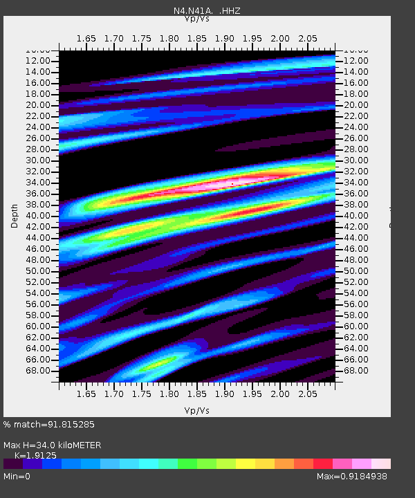
| Estimated Moho Depth: |
34.0 km |
| Estimated Crust Vp/Vs: |
1.91 |
| Assumed Crust Vp: |
6.498 km/s |
| Estimated Crust Vs: |
3.397 km/s |
| Estimated Crust Poisson's Ratio: |
0.31 |
|
| Radial Match: |
91.815285 % |
| Radial Bump: |
229 |
| Transverse Match: |
72.300385 % |
| Transverse Bump: |
369 |
| SOD ConfigId: |
751272 |
| Insert Time: |
2014-07-31 12:22:39.308 +0000 |
| GWidth: |
2.5 |
| Max Bumps: |
400 |
| Tol: |
0.001 |
|

Signal To Noise
| Channel | StoN | STA | LTA |
| N4:N41A: :HHZ:20140717T11:56:03.589996Z | 7.899009 | 6.5927975E-7 | 8.3463604E-8 |
| N4:N41A: :HHN:20140717T11:56:03.589996Z | 5.539664 | 4.086003E-7 | 7.375905E-8 |
| N4:N41A: :HHE:20140717T11:56:03.589996Z | 4.298446 | 3.003768E-7 | 6.988032E-8 |
| Arrivals |
| Ps | 5.1 SECOND |
| PpPs | 14 SECOND |
| PsPs/PpSs | 19 SECOND |


