You are here: Home > Network List > N4 - Central and EAstern US Network Stations List
> Station L48A N Adams, MI, USA > Earthquake Result Viewer
L48A N Adams, MI, USA - Earthquake Result Viewer
| Earthquake location: |
Southeastern Alaska |
| Earthquake latitude/longitude: |
60.4/-140.3 |
| Earthquake time(UTC): |
2014/07/17 (198) 11:49:32 GMT |
| Earthquake Depth: |
0.6 km |
| Earthquake Magnitude: |
5.8 MI |
| Earthquake Catalog/Contributor: |
NEIC PDE/NEIC ALERT |
|
| Network: |
N4 Central and EAstern US Network |
| Station: |
L48A N Adams, MI, USA |
| Lat/Lon: |
41.94 N/84.43 W |
| Elevation: |
369 m |
|
| Distance: |
38.2 deg |
| Az: |
92.965 deg |
| Baz: |
318.309 deg |
| Ray Param: |
0.0757122 |
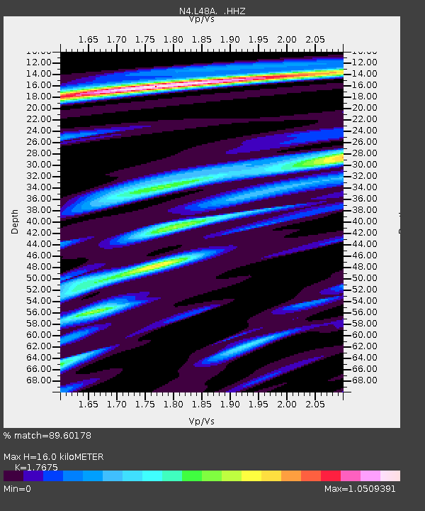
| Estimated Moho Depth: |
16.0 km |
| Estimated Crust Vp/Vs: |
1.77 |
| Assumed Crust Vp: |
6.498 km/s |
| Estimated Crust Vs: |
3.676 km/s |
| Estimated Crust Poisson's Ratio: |
0.26 |
|
| Radial Match: |
89.60178 % |
| Radial Bump: |
353 |
| Transverse Match: |
49.91077 % |
| Transverse Bump: |
400 |
| SOD ConfigId: |
751272 |
| Insert Time: |
2014-07-31 12:25:42.690 +0000 |
| GWidth: |
2.5 |
| Max Bumps: |
400 |
| Tol: |
0.001 |
|

Signal To Noise
| Channel | StoN | STA | LTA |
| N4:L48A: :HHZ:20140717T11:56:22.540009Z | 6.2838345 | 8.613928E-7 | 1.3708075E-7 |
| N4:L48A: :HHN:20140717T11:56:22.540009Z | 4.402782 | 4.85285E-7 | 1.10222345E-7 |
| N4:L48A: :HHE:20140717T11:56:22.540009Z | 4.2976713 | 3.9633537E-7 | 9.2220965E-8 |
| Arrivals |
| Ps | 2.0 SECOND |
| PpPs | 6.3 SECOND |
| PsPs/PpSs | 8.4 SECOND |


