You are here: Home > Network List > JP - Japan Meteorological Agency Seismic Network Stations List
> Station JMN Kochi Monobe > Earthquake Result Viewer
JMN Kochi Monobe - Earthquake Result Viewer
| Earthquake location: |
Samoa Islands Region |
| Earthquake latitude/longitude: |
-16.0/-172.8 |
| Earthquake time(UTC): |
2015/04/01 (091) 11:06:35 GMT |
| Earthquake Depth: |
10 km |
| Earthquake Magnitude: |
5.5 MWC, 5.5 MWC |
| Earthquake Catalog/Contributor: |
NEIC PDE/NEIC COMCAT |
|
| Network: |
JP Japan Meteorological Agency Seismic Network |
| Station: |
JMN Kochi Monobe |
| Lat/Lon: |
33.73 N/133.88 E |
| Elevation: |
550 m |
|
| Distance: |
70.9 deg |
| Az: |
315.004 deg |
| Baz: |
125.324 deg |
| Ray Param: |
0.054686274 |
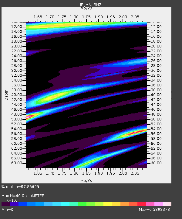
| Estimated Moho Depth: |
49.0 km |
| Estimated Crust Vp/Vs: |
1.60 |
| Assumed Crust Vp: |
6.468 km/s |
| Estimated Crust Vs: |
4.042 km/s |
| Estimated Crust Poisson's Ratio: |
0.18 |
|
| Radial Match: |
97.85625 % |
| Radial Bump: |
256 |
| Transverse Match: |
97.244385 % |
| Transverse Bump: |
361 |
| SOD ConfigId: |
7422571 |
| Insert Time: |
2019-04-18 01:06:04.789 +0000 |
| GWidth: |
2.5 |
| Max Bumps: |
400 |
| Tol: |
0.001 |
|

Signal To Noise
| Channel | StoN | STA | LTA |
| JP:JMN: :BHZ:20150401T11:17:22.55001Z | 0.5481231 | 2.190791E-6 | 3.9968963E-6 |
| JP:JMN: :BHN:20150401T11:17:22.55001Z | 1.7996463 | 6.206579E-7 | 3.4487772E-7 |
| JP:JMN: :BHE:20150401T11:17:22.55001Z | 0.5595416 | 3.2121116E-6 | 5.740613E-6 |
| Arrivals |
| Ps | 4.7 SECOND |
| PpPs | 19 SECOND |
| PsPs/PpSs | 24 SECOND |


