You are here: Home > Network List > TA - USArray Transportable Network (new EarthScope stations) Stations List
> Station I23K Minto, Yukon-Koyukuk, AK, USA > Earthquake Result Viewer
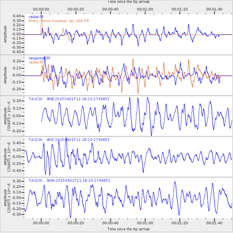
I23K Minto, Yukon-Koyukuk, AK, USA - Earthquake Result Viewer
*The percent match for this event was below the threshold and hence no stack was calculated.
| Earthquake location: |
Samoa Islands Region |
| Earthquake latitude/longitude: |
-16.0/-172.8 |
| Earthquake time(UTC): |
2015/04/01 (091) 11:06:35 GMT |
| Earthquake Depth: |
10 km |
| Earthquake Magnitude: |
5.5 MWC, 5.5 MWC |
| Earthquake Catalog/Contributor: |
NEIC PDE/NEIC COMCAT |
|
| Network: |
TA USArray Transportable Network (new EarthScope stations) |
| Station: |
I23K Minto, Yukon-Koyukuk, AK, USA |
| Lat/Lon: |
65.15 N/149.36 W |
| Elevation: |
149 m |
|
| Distance: |
82.9 deg |
| Az: |
9.768 deg |
| Baz: |
202.709 deg |
| Ray Param: |
$rayparam |
*The percent match for this event was below the threshold and hence was not used in the summary stack. |
|
| Radial Match: |
67.702065 % |
| Radial Bump: |
400 |
| Transverse Match: |
53.68449 % |
| Transverse Bump: |
400 |
| SOD ConfigId: |
7422571 |
| Insert Time: |
2019-04-18 01:07:47.051 +0000 |
| GWidth: |
2.5 |
| Max Bumps: |
400 |
| Tol: |
0.001 |
|
Signal To Noise
| Channel | StoN | STA | LTA |
| TA:I23K: :BHZ:20150401T11:18:29.274985Z | 2.8188772 | 2.372359E-7 | 8.4159716E-8 |
| TA:I23K: :BHN:20150401T11:18:29.274985Z | 0.963873 | 1.1334456E-7 | 1.1759283E-7 |
| TA:I23K: :BHE:20150401T11:18:29.274985Z | 1.3112899 | 1.0427092E-7 | 7.951782E-8 |
| Arrivals |
| Ps | |
| PpPs | |
| PsPs/PpSs | |


