You are here: Home > Network List > TA - USArray Transportable Network (new EarthScope stations) Stations List
> Station TUL1 Leonard, OK, USA > Earthquake Result Viewer
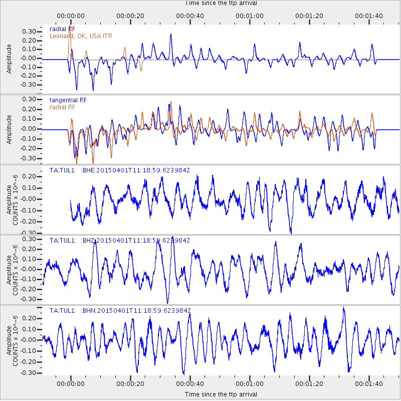
TUL1 Leonard, OK, USA - Earthquake Result Viewer
*The percent match for this event was below the threshold and hence no stack was calculated.
| Earthquake location: |
Samoa Islands Region |
| Earthquake latitude/longitude: |
-16.0/-172.8 |
| Earthquake time(UTC): |
2015/04/01 (091) 11:06:35 GMT |
| Earthquake Depth: |
10 km |
| Earthquake Magnitude: |
5.5 MWC, 5.5 MWC |
| Earthquake Catalog/Contributor: |
NEIC PDE/NEIC COMCAT |
|
| Network: |
TA USArray Transportable Network (new EarthScope stations) |
| Station: |
TUL1 Leonard, OK, USA |
| Lat/Lon: |
35.91 N/95.79 W |
| Elevation: |
256 m |
|
| Distance: |
89.1 deg |
| Az: |
52.299 deg |
| Baz: |
249.597 deg |
| Ray Param: |
$rayparam |
*The percent match for this event was below the threshold and hence was not used in the summary stack. |
|
| Radial Match: |
63.249615 % |
| Radial Bump: |
400 |
| Transverse Match: |
52.028706 % |
| Transverse Bump: |
400 |
| SOD ConfigId: |
7422571 |
| Insert Time: |
2019-04-18 01:07:53.347 +0000 |
| GWidth: |
2.5 |
| Max Bumps: |
400 |
| Tol: |
0.001 |
|
Signal To Noise
| Channel | StoN | STA | LTA |
| TA:TUL1: :BHZ:20150401T11:18:59.623984Z | 0.52912176 | 7.0640816E-8 | 1.335058E-7 |
| TA:TUL1: :BHN:20150401T11:18:59.623984Z | 0.53035516 | 5.269595E-8 | 9.935974E-8 |
| TA:TUL1: :BHE:20150401T11:18:59.623984Z | 1.1224563 | 1.0904673E-7 | 9.715009E-8 |
| Arrivals |
| Ps | |
| PpPs | |
| PsPs/PpSs | |


