You are here: Home > Network List > TA - USArray Transportable Network (new EarthScope stations) Stations List
> Station I51A Listowel, ON, CAN > Earthquake Result Viewer
I51A Listowel, ON, CAN - Earthquake Result Viewer

| Earthquake location: |
Southeastern Alaska |
| Earthquake latitude/longitude: |
60.4/-140.3 |
| Earthquake time(UTC): |
2014/07/17 (198) 11:49:32 GMT |
| Earthquake Depth: |
0.6 km |
| Earthquake Magnitude: |
5.8 MI |
| Earthquake Catalog/Contributor: |
NEIC PDE/NEIC ALERT |
|
| Network: |
TA USArray Transportable Network (new EarthScope stations) |
| Station: |
I51A Listowel, ON, CAN |
| Lat/Lon: |
43.80 N/81.02 W |
| Elevation: |
376 m |
|
| Distance: |
38.5 deg |
| Az: |
87.965 deg |
| Baz: |
316.701 deg |
| Ray Param: |
0.075525306 |
| Estimated Moho Depth: |
48.75 km |
| Estimated Crust Vp/Vs: |
1.73 |
| Assumed Crust Vp: |
6.53 km/s |
| Estimated Crust Vs: |
3.775 km/s |
| Estimated Crust Poisson's Ratio: |
0.25 |
|
| Radial Match: |
88.66384 % |
| Radial Bump: |
284 |
| Transverse Match: |
52.187717 % |
| Transverse Bump: |
400 |
| SOD ConfigId: |
751272 |
| Insert Time: |
2014-07-31 12:36:38.348 +0000 |
| GWidth: |
2.5 |
| Max Bumps: |
400 |
| Tol: |
0.001 |
|
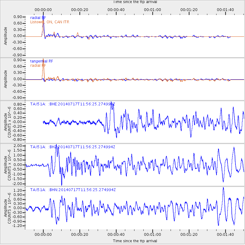
Signal To Noise
| Channel | StoN | STA | LTA |
| TA:I51A: :BHZ:20140717T11:56:25.274994Z | 5.255919 | 4.6121048E-7 | 8.775068E-8 |
| TA:I51A: :BHN:20140717T11:56:25.274994Z | 2.811527 | 2.706096E-7 | 9.625005E-8 |
| TA:I51A: :BHE:20140717T11:56:25.274994Z | 3.185285 | 1.842652E-7 | 5.7848887E-8 |
| Arrivals |
| Ps | 5.9 SECOND |
| PpPs | 19 SECOND |
| PsPs/PpSs | 25 SECOND |


