You are here: Home > Network List > NE - New England Seismic Network Stations List
> Station EMMW Machias, ME, USA > Earthquake Result Viewer
EMMW Machias, ME, USA - Earthquake Result Viewer
*The percent match for this event was below the threshold and hence no stack was calculated.
| Earthquake location: |
Near Coast Of Peru |
| Earthquake latitude/longitude: |
-10.6/-78.0 |
| Earthquake time(UTC): |
2015/04/01 (091) 16:45:21 GMT |
| Earthquake Depth: |
48 km |
| Earthquake Magnitude: |
5.5 MW |
| Earthquake Catalog/Contributor: |
ISC/ISC |
|
| Network: |
NE New England Seismic Network |
| Station: |
EMMW Machias, ME, USA |
| Lat/Lon: |
44.71 N/67.46 W |
| Elevation: |
35 m |
|
| Distance: |
55.8 deg |
| Az: |
9.088 deg |
| Baz: |
192.581 deg |
| Ray Param: |
$rayparam |
*The percent match for this event was below the threshold and hence was not used in the summary stack. |
|
| Radial Match: |
59.491383 % |
| Radial Bump: |
400 |
| Transverse Match: |
38.665688 % |
| Transverse Bump: |
400 |
| SOD ConfigId: |
7422571 |
| Insert Time: |
2019-04-18 01:12:54.693 +0000 |
| GWidth: |
2.5 |
| Max Bumps: |
400 |
| Tol: |
0.001 |
|
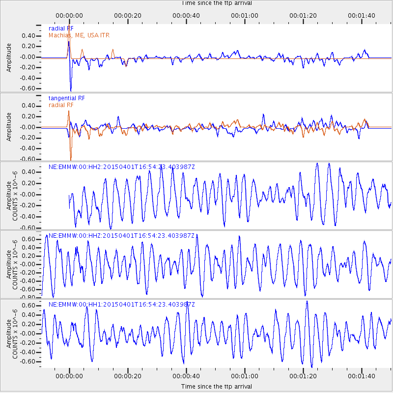
Signal To Noise
| Channel | StoN | STA | LTA |
| NE:EMMW:00:HHZ:20150401T16:54:23.403987Z | 0.74480593 | 2.570418E-7 | 3.4511245E-7 |
| NE:EMMW:00:HH1:20150401T16:54:23.403987Z | 0.8426094 | 2.1773637E-7 | 2.5840723E-7 |
| NE:EMMW:00:HH2:20150401T16:54:23.403987Z | 1.114214 | 2.896856E-7 | 2.5999103E-7 |
| Arrivals |
| Ps | |
| PpPs | |
| PsPs/PpSs | |


