You are here: Home > Network List > TA - USArray Transportable Network (new EarthScope stations) Stations List
> Station MSTX Muleshoe, TX, USA > Earthquake Result Viewer
MSTX Muleshoe, TX, USA - Earthquake Result Viewer
| Earthquake location: |
Southeastern Alaska |
| Earthquake latitude/longitude: |
60.4/-140.3 |
| Earthquake time(UTC): |
2014/07/17 (198) 11:49:32 GMT |
| Earthquake Depth: |
0.6 km |
| Earthquake Magnitude: |
5.8 MI |
| Earthquake Catalog/Contributor: |
NEIC PDE/NEIC ALERT |
|
| Network: |
TA USArray Transportable Network (new EarthScope stations) |
| Station: |
MSTX Muleshoe, TX, USA |
| Lat/Lon: |
33.97 N/102.77 W |
| Elevation: |
1167 m |
|
| Distance: |
35.9 deg |
| Az: |
120.23 deg |
| Baz: |
328.899 deg |
| Ray Param: |
0.0769913 |
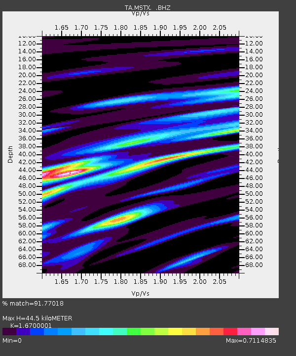
| Estimated Moho Depth: |
44.5 km |
| Estimated Crust Vp/Vs: |
1.67 |
| Assumed Crust Vp: |
6.129 km/s |
| Estimated Crust Vs: |
3.67 km/s |
| Estimated Crust Poisson's Ratio: |
0.22 |
|
| Radial Match: |
91.77018 % |
| Radial Bump: |
344 |
| Transverse Match: |
79.36699 % |
| Transverse Bump: |
331 |
| SOD ConfigId: |
751272 |
| Insert Time: |
2014-07-31 12:39:33.138 +0000 |
| GWidth: |
2.5 |
| Max Bumps: |
400 |
| Tol: |
0.001 |
|

Signal To Noise
| Channel | StoN | STA | LTA |
| TA:MSTX: :BHZ:20140717T11:56:02.950012Z | 15.325788 | 1.6089467E-6 | 1.0498297E-7 |
| TA:MSTX: :BHN:20140717T11:56:02.950012Z | 7.694087 | 6.5048687E-7 | 8.454374E-8 |
| TA:MSTX: :BHE:20140717T11:56:02.950012Z | 4.117559 | 3.9056124E-7 | 9.4852616E-8 |
| Arrivals |
| Ps | 5.2 SECOND |
| PpPs | 18 SECOND |
| PsPs/PpSs | 23 SECOND |


