You are here: Home > Network List > TA - USArray Transportable Network (new EarthScope stations) Stations List
> Station O56A Blue Knob State Park, Imler, PA, USA > Earthquake Result Viewer
O56A Blue Knob State Park, Imler, PA, USA - Earthquake Result Viewer
| Earthquake location: |
Southeastern Alaska |
| Earthquake latitude/longitude: |
60.4/-140.3 |
| Earthquake time(UTC): |
2014/07/17 (198) 11:49:32 GMT |
| Earthquake Depth: |
0.6 km |
| Earthquake Magnitude: |
5.8 MI |
| Earthquake Catalog/Contributor: |
NEIC PDE/NEIC ALERT |
|
| Network: |
TA USArray Transportable Network (new EarthScope stations) |
| Station: |
O56A Blue Knob State Park, Imler, PA, USA |
| Lat/Lon: |
40.27 N/78.57 W |
| Elevation: |
684 m |
|
| Distance: |
42.4 deg |
| Az: |
89.5 deg |
| Baz: |
319.509 deg |
| Ray Param: |
0.07322262 |
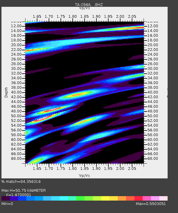
| Estimated Moho Depth: |
50.75 km |
| Estimated Crust Vp/Vs: |
1.67 |
| Assumed Crust Vp: |
6.121 km/s |
| Estimated Crust Vs: |
3.665 km/s |
| Estimated Crust Poisson's Ratio: |
0.22 |
|
| Radial Match: |
84.356316 % |
| Radial Bump: |
377 |
| Transverse Match: |
46.002163 % |
| Transverse Bump: |
370 |
| SOD ConfigId: |
751272 |
| Insert Time: |
2014-07-31 12:40:43.069 +0000 |
| GWidth: |
2.5 |
| Max Bumps: |
400 |
| Tol: |
0.001 |
|

Signal To Noise
| Channel | StoN | STA | LTA |
| TA:O56A: :BHZ:20140717T11:56:57.100006Z | 3.3957949 | 4.5212855E-7 | 1.3314366E-7 |
| TA:O56A: :BHN:20140717T11:56:57.100006Z | 1.790835 | 2.0380779E-7 | 1.1380601E-7 |
| TA:O56A: :BHE:20140717T11:56:57.100006Z | 1.0879393 | 1.5068456E-7 | 1.3850456E-7 |
| Arrivals |
| Ps | 5.9 SECOND |
| PpPs | 21 SECOND |
| PsPs/PpSs | 27 SECOND |


