You are here: Home > Network List > TA - USArray Transportable Network (new EarthScope stations) Stations List
> Station Q58A Fox Den Farm, The Plains, VA, USA > Earthquake Result Viewer
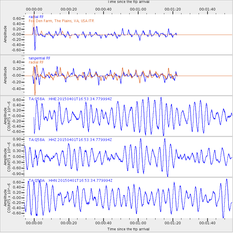
Q58A Fox Den Farm, The Plains, VA, USA - Earthquake Result Viewer
*The percent match for this event was below the threshold and hence no stack was calculated.
| Earthquake location: |
Near Coast Of Peru |
| Earthquake latitude/longitude: |
-10.6/-78.0 |
| Earthquake time(UTC): |
2015/04/01 (091) 16:45:21 GMT |
| Earthquake Depth: |
48 km |
| Earthquake Magnitude: |
5.5 MW |
| Earthquake Catalog/Contributor: |
ISC/ISC |
|
| Network: |
TA USArray Transportable Network (new EarthScope stations) |
| Station: |
Q58A Fox Den Farm, The Plains, VA, USA |
| Lat/Lon: |
38.94 N/77.68 W |
| Elevation: |
182 m |
|
| Distance: |
49.2 deg |
| Az: |
0.346 deg |
| Baz: |
180.436 deg |
| Ray Param: |
$rayparam |
*The percent match for this event was below the threshold and hence was not used in the summary stack. |
|
| Radial Match: |
59.392258 % |
| Radial Bump: |
340 |
| Transverse Match: |
49.04999 % |
| Transverse Bump: |
400 |
| SOD ConfigId: |
7422571 |
| Insert Time: |
2019-04-18 01:14:33.255 +0000 |
| GWidth: |
2.5 |
| Max Bumps: |
400 |
| Tol: |
0.001 |
|
Signal To Noise
| Channel | StoN | STA | LTA |
| TA:Q58A: :HHZ:20150401T16:53:34.779994Z | 0.97789097 | 2.810902E-7 | 2.8744535E-7 |
| TA:Q58A: :HHN:20150401T16:53:34.779994Z | 2.1015065 | 4.4635559E-7 | 2.1239791E-7 |
| TA:Q58A: :HHE:20150401T16:53:34.779994Z | 1.2692028 | 3.284502E-7 | 2.5878464E-7 |
| Arrivals |
| Ps | |
| PpPs | |
| PsPs/PpSs | |


