You are here: Home > Network List > TA - USArray Transportable Network (new EarthScope stations) Stations List
> Station O60A Telford, PA, USA > Earthquake Result Viewer
O60A Telford, PA, USA - Earthquake Result Viewer
| Earthquake location: |
Southeastern Alaska |
| Earthquake latitude/longitude: |
60.4/-140.3 |
| Earthquake time(UTC): |
2014/07/17 (198) 11:49:32 GMT |
| Earthquake Depth: |
0.6 km |
| Earthquake Magnitude: |
5.8 MI |
| Earthquake Catalog/Contributor: |
NEIC PDE/NEIC ALERT |
|
| Network: |
TA USArray Transportable Network (new EarthScope stations) |
| Station: |
O60A Telford, PA, USA |
| Lat/Lon: |
40.32 N/75.40 W |
| Elevation: |
70 m |
|
| Distance: |
43.9 deg |
| Az: |
86.764 deg |
| Baz: |
319.55 deg |
| Ray Param: |
0.07225963 |
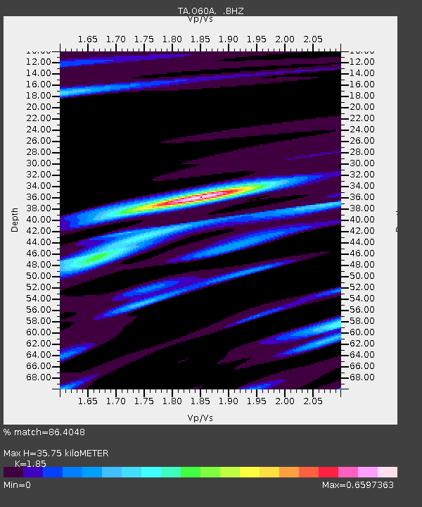
| Estimated Moho Depth: |
35.75 km |
| Estimated Crust Vp/Vs: |
1.85 |
| Assumed Crust Vp: |
6.283 km/s |
| Estimated Crust Vs: |
3.396 km/s |
| Estimated Crust Poisson's Ratio: |
0.29 |
|
| Radial Match: |
86.4048 % |
| Radial Bump: |
256 |
| Transverse Match: |
55.718166 % |
| Transverse Bump: |
400 |
| SOD ConfigId: |
751272 |
| Insert Time: |
2014-07-31 12:41:16.819 +0000 |
| GWidth: |
2.5 |
| Max Bumps: |
400 |
| Tol: |
0.001 |
|

Signal To Noise
| Channel | StoN | STA | LTA |
| TA:O60A: :BHZ:20140717T11:57:09.475006Z | 3.9456818 | 4.832293E-7 | 1.2247042E-7 |
| TA:O60A: :BHN:20140717T11:57:09.475006Z | 1.8182596 | 1.8036106E-7 | 9.919434E-8 |
| TA:O60A: :BHE:20140717T11:57:09.475006Z | 2.808091 | 1.9799168E-7 | 7.0507575E-8 |
| Arrivals |
| Ps | 5.1 SECOND |
| PpPs | 15 SECOND |
| PsPs/PpSs | 20 SECOND |


