You are here: Home > Network List > US - United States National Seismic Network Stations List
> Station AMTX Amarillo, Texas, USA > Earthquake Result Viewer
AMTX Amarillo, Texas, USA - Earthquake Result Viewer
*The percent match for this event was below the threshold and hence no stack was calculated.
| Earthquake location: |
Near Coast Of Peru |
| Earthquake latitude/longitude: |
-10.6/-78.0 |
| Earthquake time(UTC): |
2015/04/01 (091) 16:45:21 GMT |
| Earthquake Depth: |
48 km |
| Earthquake Magnitude: |
5.5 MW |
| Earthquake Catalog/Contributor: |
ISC/ISC |
|
| Network: |
US United States National Seismic Network |
| Station: |
AMTX Amarillo, Texas, USA |
| Lat/Lon: |
34.53 N/101.41 W |
| Elevation: |
1010 m |
|
| Distance: |
50.0 deg |
| Az: |
334.679 deg |
| Baz: |
149.377 deg |
| Ray Param: |
$rayparam |
*The percent match for this event was below the threshold and hence was not used in the summary stack. |
|
| Radial Match: |
49.012142 % |
| Radial Bump: |
400 |
| Transverse Match: |
42.499447 % |
| Transverse Bump: |
400 |
| SOD ConfigId: |
7422571 |
| Insert Time: |
2019-04-18 01:14:58.394 +0000 |
| GWidth: |
2.5 |
| Max Bumps: |
400 |
| Tol: |
0.001 |
|
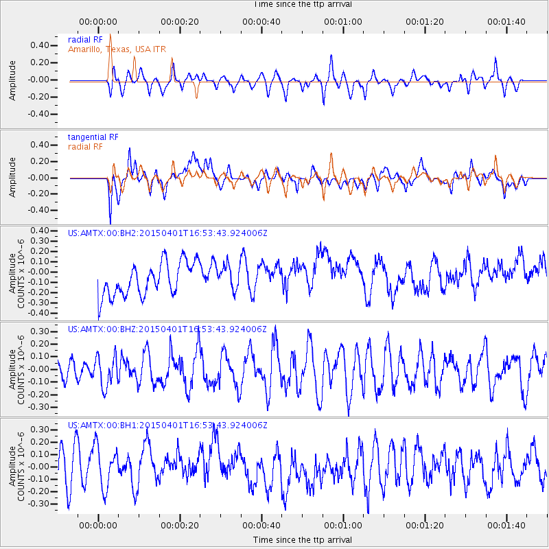
Signal To Noise
| Channel | StoN | STA | LTA |
| US:AMTX:00:BHZ:20150401T16:53:43.924006Z | 0.9386547 | 1.2304561E-7 | 1.3108719E-7 |
| US:AMTX:00:BH1:20150401T16:53:43.924006Z | 1.0221573 | 1.9556775E-7 | 1.9132844E-7 |
| US:AMTX:00:BH2:20150401T16:53:43.924006Z | 0.9306706 | 1.4828558E-7 | 1.5933196E-7 |
| Arrivals |
| Ps | |
| PpPs | |
| PsPs/PpSs | |


