You are here: Home > Network List > TA - USArray Transportable Network (new EarthScope stations) Stations List
> Station S54A Dingess, Beckley, WV, USA > Earthquake Result Viewer
S54A Dingess, Beckley, WV, USA - Earthquake Result Viewer
| Earthquake location: |
Southeastern Alaska |
| Earthquake latitude/longitude: |
60.4/-140.3 |
| Earthquake time(UTC): |
2014/07/17 (198) 11:49:32 GMT |
| Earthquake Depth: |
0.6 km |
| Earthquake Magnitude: |
5.8 MI |
| Earthquake Catalog/Contributor: |
NEIC PDE/NEIC ALERT |
|
| Network: |
TA USArray Transportable Network (new EarthScope stations) |
| Station: |
S54A Dingess, Beckley, WV, USA |
| Lat/Lon: |
37.80 N/81.31 W |
| Elevation: |
636 m |
|
| Distance: |
42.9 deg |
| Az: |
94.25 deg |
| Baz: |
321.281 deg |
| Ray Param: |
0.07290068 |
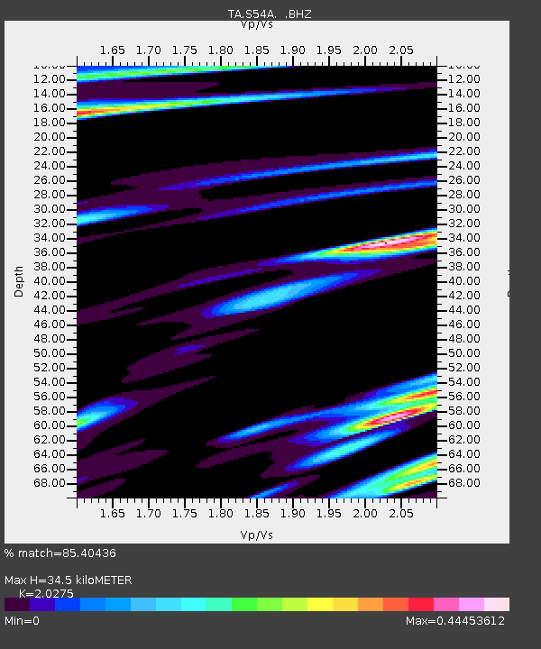
| Estimated Moho Depth: |
34.5 km |
| Estimated Crust Vp/Vs: |
2.03 |
| Assumed Crust Vp: |
6.159 km/s |
| Estimated Crust Vs: |
3.038 km/s |
| Estimated Crust Poisson's Ratio: |
0.34 |
|
| Radial Match: |
85.40436 % |
| Radial Bump: |
317 |
| Transverse Match: |
49.539814 % |
| Transverse Bump: |
400 |
| SOD ConfigId: |
751272 |
| Insert Time: |
2014-07-31 12:43:20.196 +0000 |
| GWidth: |
2.5 |
| Max Bumps: |
400 |
| Tol: |
0.001 |
|

Signal To Noise
| Channel | StoN | STA | LTA |
| TA:S54A: :BHZ:20140717T11:57:01.450012Z | 3.3707635 | 3.8776184E-7 | 1.150368E-7 |
| TA:S54A: :BHN:20140717T11:57:01.450012Z | 2.7801785 | 2.2108806E-7 | 7.952297E-8 |
| TA:S54A: :BHE:20140717T11:57:01.450012Z | 2.0685565 | 1.5237553E-7 | 7.366273E-8 |
| Arrivals |
| Ps | 6.1 SECOND |
| PpPs | 16 SECOND |
| PsPs/PpSs | 22 SECOND |


