You are here: Home > Network List > TA - USArray Transportable Network (new EarthScope stations) Stations List
> Station T54A Tazewell, VA, USA > Earthquake Result Viewer
T54A Tazewell, VA, USA - Earthquake Result Viewer
| Earthquake location: |
Southeastern Alaska |
| Earthquake latitude/longitude: |
60.4/-140.3 |
| Earthquake time(UTC): |
2014/07/17 (198) 11:49:32 GMT |
| Earthquake Depth: |
0.6 km |
| Earthquake Magnitude: |
5.8 MI |
| Earthquake Catalog/Contributor: |
NEIC PDE/NEIC ALERT |
|
| Network: |
TA USArray Transportable Network (new EarthScope stations) |
| Station: |
T54A Tazewell, VA, USA |
| Lat/Lon: |
37.06 N/81.58 W |
| Elevation: |
852 m |
|
| Distance: |
43.4 deg |
| Az: |
95.162 deg |
| Baz: |
321.786 deg |
| Ray Param: |
0.072617 |
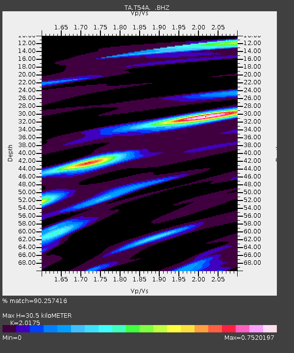
| Estimated Moho Depth: |
30.5 km |
| Estimated Crust Vp/Vs: |
2.02 |
| Assumed Crust Vp: |
6.159 km/s |
| Estimated Crust Vs: |
3.053 km/s |
| Estimated Crust Poisson's Ratio: |
0.34 |
|
| Radial Match: |
90.257416 % |
| Radial Bump: |
253 |
| Transverse Match: |
51.78083 % |
| Transverse Bump: |
400 |
| SOD ConfigId: |
751272 |
| Insert Time: |
2014-07-31 12:43:56.225 +0000 |
| GWidth: |
2.5 |
| Max Bumps: |
400 |
| Tol: |
0.001 |
|
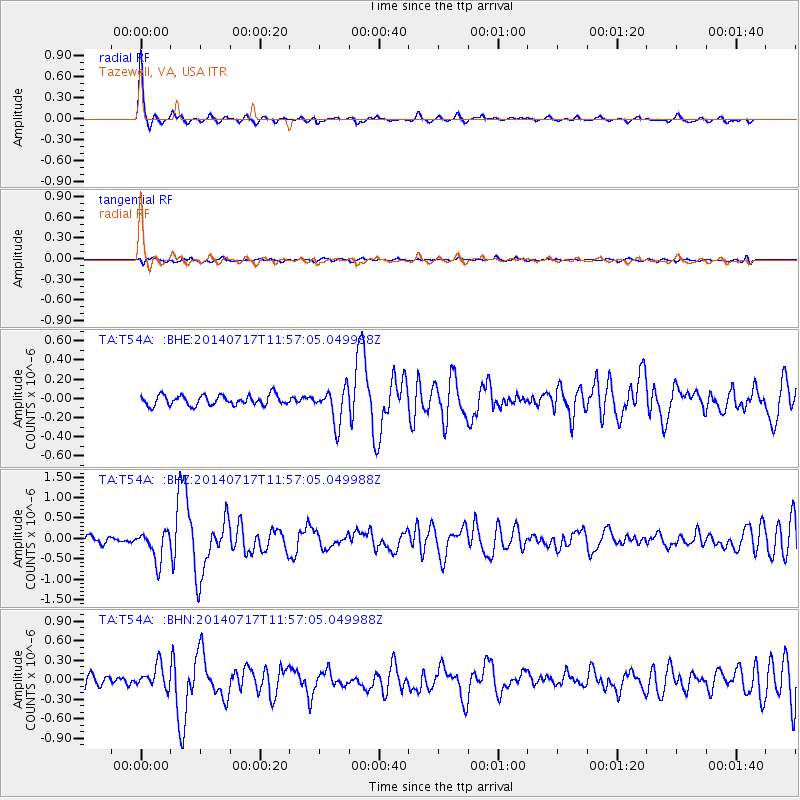
Signal To Noise
| Channel | StoN | STA | LTA |
| TA:T54A: :BHZ:20140717T11:57:05.049988Z | 3.7810228 | 3.6396236E-7 | 9.626029E-8 |
| TA:T54A: :BHN:20140717T11:57:05.049988Z | 2.1360102 | 1.6858338E-7 | 7.892444E-8 |
| TA:T54A: :BHE:20140717T11:57:05.049988Z | 3.4328654 | 1.8177974E-7 | 5.2952775E-8 |
| Arrivals |
| Ps | 5.3 SECOND |
| PpPs | 14 SECOND |
| PsPs/PpSs | 19 SECOND |


