You are here: Home > Network List > II - Global Seismograph Network (GSN - IRIS/IDA) Stations List
> Station LVZ Lovozero, Russia > Earthquake Result Viewer
LVZ Lovozero, Russia - Earthquake Result Viewer
| Earthquake location: |
Kuril Islands |
| Earthquake latitude/longitude: |
43.9/147.9 |
| Earthquake time(UTC): |
1994/10/09 (282) 07:55:38 GMT |
| Earthquake Depth: |
23 km |
| Earthquake Magnitude: |
6.5 MB, 7.0 MS, 6.7 UNKNOWN, 7.3 MW |
| Earthquake Catalog/Contributor: |
WHDF/NEIC |
|
| Network: |
II Global Seismograph Network (GSN - IRIS/IDA) |
| Station: |
LVZ Lovozero, Russia |
| Lat/Lon: |
67.90 N/34.65 E |
| Elevation: |
630 m |
|
| Distance: |
57.9 deg |
| Az: |
335.764 deg |
| Baz: |
51.64 deg |
| Ray Param: |
0.063171834 |
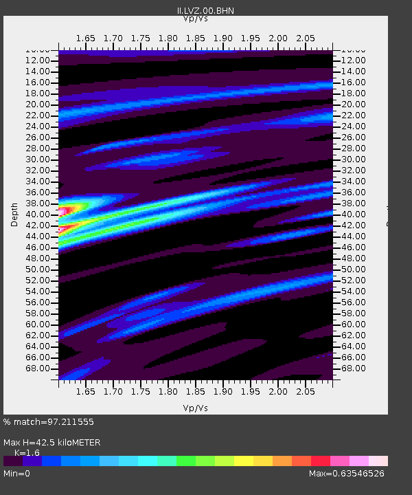
| Estimated Moho Depth: |
42.5 km |
| Estimated Crust Vp/Vs: |
1.60 |
| Assumed Crust Vp: |
6.367 km/s |
| Estimated Crust Vs: |
3.979 km/s |
| Estimated Crust Poisson's Ratio: |
0.18 |
|
| Radial Match: |
97.211555 % |
| Radial Bump: |
315 |
| Transverse Match: |
79.66411 % |
| Transverse Bump: |
400 |
| SOD ConfigId: |
61242 |
| Insert Time: |
2010-03-02 00:13:04.476 +0000 |
| GWidth: |
2.5 |
| Max Bumps: |
400 |
| Tol: |
0.001 |
|

Signal To Noise
| Channel | StoN | STA | LTA |
| II:LVZ:00:BHN:19941009T08:04:57.078003Z | 6.7411475 | 2.1598607E-6 | 3.2039955E-7 |
| II:LVZ:00:BHE:19941009T08:04:57.080017Z | 12.093781 | 2.6300022E-6 | 2.1746732E-7 |
| II:LVZ:00:BHZ:19941009T08:04:57.078003Z | 9.250461 | 6.019474E-6 | 6.507215E-7 |
| Arrivals |
| Ps | 4.2 SECOND |
| PpPs | 16 SECOND |
| PsPs/PpSs | 21 SECOND |


