You are here: Home > Network List > TA - USArray Transportable Network (new EarthScope stations) Stations List
> Station X58A Rowland, NC, USA > Earthquake Result Viewer
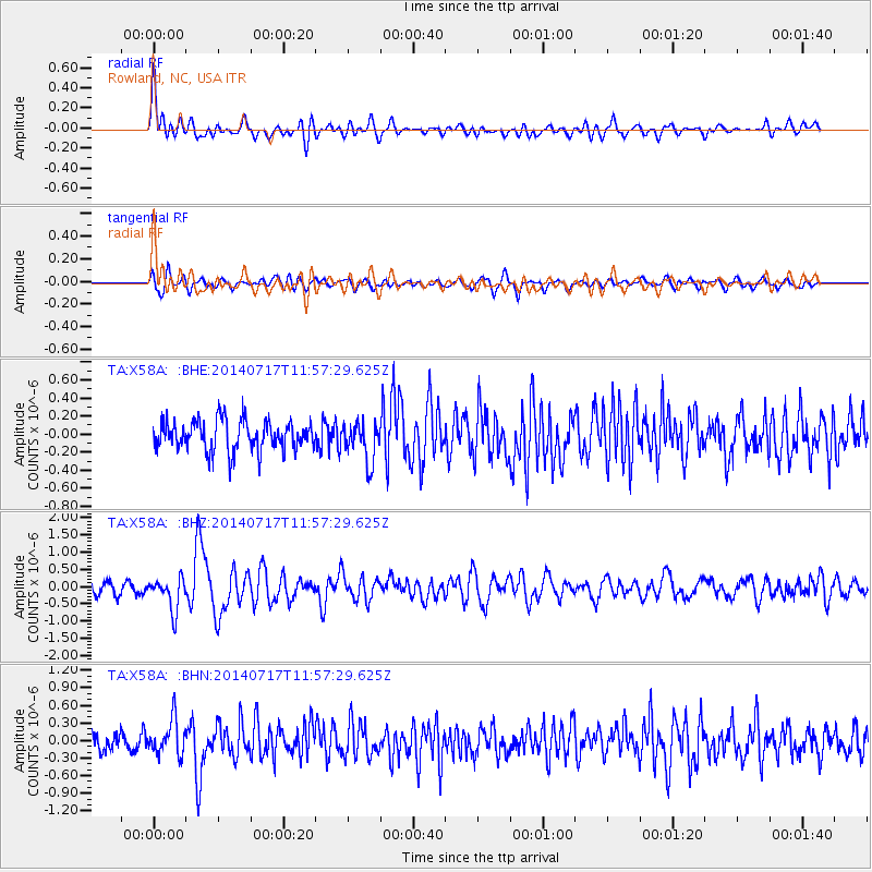
X58A Rowland, NC, USA - Earthquake Result Viewer
*The percent match for this event was below the threshold and hence no stack was calculated.
| Earthquake location: |
Southeastern Alaska |
| Earthquake latitude/longitude: |
60.4/-140.3 |
| Earthquake time(UTC): |
2014/07/17 (198) 11:49:32 GMT |
| Earthquake Depth: |
0.6 km |
| Earthquake Magnitude: |
5.8 MI |
| Earthquake Catalog/Contributor: |
NEIC PDE/NEIC ALERT |
|
| Network: |
TA USArray Transportable Network (new EarthScope stations) |
| Station: |
X58A Rowland, NC, USA |
| Lat/Lon: |
34.55 N/79.34 W |
| Elevation: |
45 m |
|
| Distance: |
46.5 deg |
| Az: |
95.275 deg |
| Baz: |
323.17 deg |
| Ray Param: |
$rayparam |
*The percent match for this event was below the threshold and hence was not used in the summary stack. |
|
| Radial Match: |
71.453766 % |
| Radial Bump: |
400 |
| Transverse Match: |
67.613754 % |
| Transverse Bump: |
400 |
| SOD ConfigId: |
751272 |
| Insert Time: |
2014-07-31 12:46:30.488 +0000 |
| GWidth: |
2.5 |
| Max Bumps: |
400 |
| Tol: |
0.001 |
|
Signal To Noise
| Channel | StoN | STA | LTA |
| TA:X58A: :BHZ:20140717T11:57:29.625Z | 2.9722328 | 4.707381E-7 | 1.583786E-7 |
| TA:X58A: :BHN:20140717T11:57:29.625Z | 1.8685586 | 2.942566E-7 | 1.5747786E-7 |
| TA:X58A: :BHE:20140717T11:57:29.625Z | 1.3129439 | 2.193974E-7 | 1.6710342E-7 |
| Arrivals |
| Ps | |
| PpPs | |
| PsPs/PpSs | |


