You are here: Home > Network List > YN10 - San Jacinto Fault Zone Stations List
> Station RHIL RHIL > Earthquake Result Viewer
RHIL RHIL - Earthquake Result Viewer
| Earthquake location: |
Southeastern Alaska |
| Earthquake latitude/longitude: |
60.4/-140.3 |
| Earthquake time(UTC): |
2014/07/17 (198) 11:49:32 GMT |
| Earthquake Depth: |
0.6 km |
| Earthquake Magnitude: |
5.8 MI |
| Earthquake Catalog/Contributor: |
NEIC PDE/NEIC ALERT |
|
| Network: |
YN San Jacinto Fault Zone |
| Station: |
RHIL RHIL |
| Lat/Lon: |
33.67 N/116.77 W |
| Elevation: |
1557 m |
|
| Distance: |
30.8 deg |
| Az: |
139.4 deg |
| Baz: |
337.186 deg |
| Ray Param: |
0.07924087 |
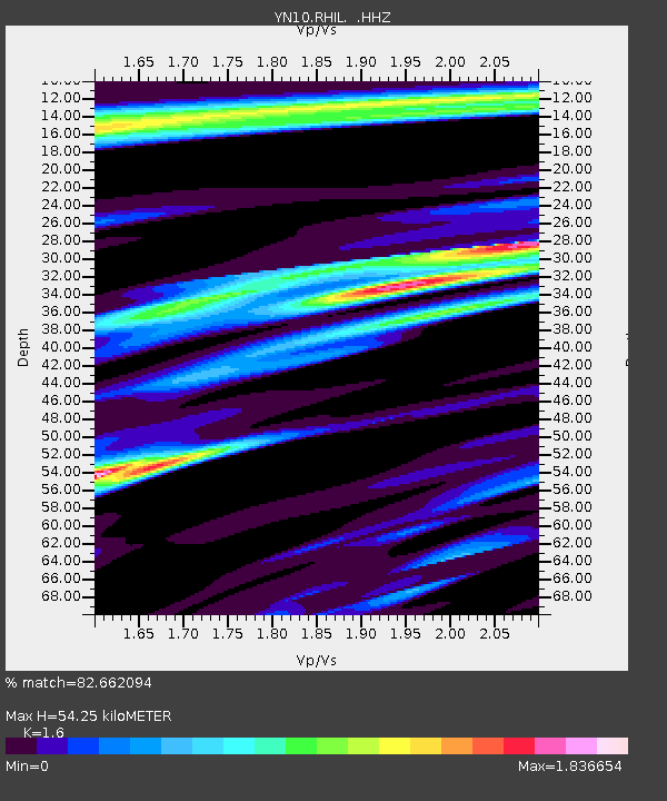
| Estimated Moho Depth: |
54.25 km |
| Estimated Crust Vp/Vs: |
1.60 |
| Assumed Crust Vp: |
6.264 km/s |
| Estimated Crust Vs: |
3.915 km/s |
| Estimated Crust Poisson's Ratio: |
0.18 |
|
| Radial Match: |
82.662094 % |
| Radial Bump: |
400 |
| Transverse Match: |
42.694397 % |
| Transverse Bump: |
400 |
| SOD ConfigId: |
751272 |
| Insert Time: |
2014-07-31 12:52:51.289 +0000 |
| GWidth: |
2.5 |
| Max Bumps: |
400 |
| Tol: |
0.001 |
|

Signal To Noise
| Channel | StoN | STA | LTA |
| YN:RHIL: :HHZ:20140717T11:55:18.778992Z | 3.8623455 | 4.967326E-7 | 1.2860906E-7 |
| YN:RHIL: :HHN:20140717T11:55:18.778992Z | 2.0422134 | 4.5206826E-7 | 2.213619E-7 |
| YN:RHIL: :HHE:20140717T11:55:18.778992Z | 1.7103068 | 2.572603E-7 | 1.5041763E-7 |
| Arrivals |
| Ps | 5.7 SECOND |
| PpPs | 21 SECOND |
| PsPs/PpSs | 26 SECOND |


