You are here: Home > Network List > AK - Alaska Regional Network Stations List
> Station WAT3 Susitna Watana 3, AK, USA > Earthquake Result Viewer
WAT3 Susitna Watana 3, AK, USA - Earthquake Result Viewer
| Earthquake location: |
Fiji Islands Region |
| Earthquake latitude/longitude: |
-17.8/-178.7 |
| Earthquake time(UTC): |
2015/04/02 (092) 04:10:09 GMT |
| Earthquake Depth: |
536 km |
| Earthquake Magnitude: |
6.0 MWP |
| Earthquake Catalog/Contributor: |
NEIC PDE/NEIC COMCAT |
|
| Network: |
AK Alaska Regional Network |
| Station: |
WAT3 Susitna Watana 3, AK, USA |
| Lat/Lon: |
62.68 N/148.54 W |
| Elevation: |
1500 m |
|
| Distance: |
83.6 deg |
| Az: |
13.475 deg |
| Baz: |
208.764 deg |
| Ray Param: |
0.04448865 |
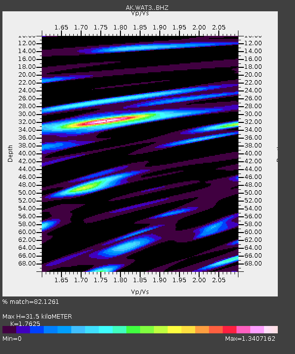
| Estimated Moho Depth: |
31.5 km |
| Estimated Crust Vp/Vs: |
1.76 |
| Assumed Crust Vp: |
6.566 km/s |
| Estimated Crust Vs: |
3.725 km/s |
| Estimated Crust Poisson's Ratio: |
0.26 |
|
| Radial Match: |
82.1261 % |
| Radial Bump: |
400 |
| Transverse Match: |
65.09836 % |
| Transverse Bump: |
400 |
| SOD ConfigId: |
7422571 |
| Insert Time: |
2019-04-18 01:18:04.631 +0000 |
| GWidth: |
2.5 |
| Max Bumps: |
400 |
| Tol: |
0.001 |
|

Signal To Noise
| Channel | StoN | STA | LTA |
| AK:WAT3: :BHZ:20150402T04:21:09.267986Z | 30.066126 | 2.3457608E-6 | 7.802005E-8 |
| AK:WAT3: :BHN:20150402T04:21:09.267986Z | 6.707188 | 8.355029E-7 | 1.2456829E-7 |
| AK:WAT3: :BHE:20150402T04:21:09.267986Z | 5.3409653 | 5.809828E-7 | 1.0877862E-7 |
| Arrivals |
| Ps | 3.8 SECOND |
| PpPs | 13 SECOND |
| PsPs/PpSs | 17 SECOND |


