You are here: Home > Network List > II - Global Seismograph Network (GSN - IRIS/IDA) Stations List
> Station WRAB Tennant Creek, NT, Australia > Earthquake Result Viewer
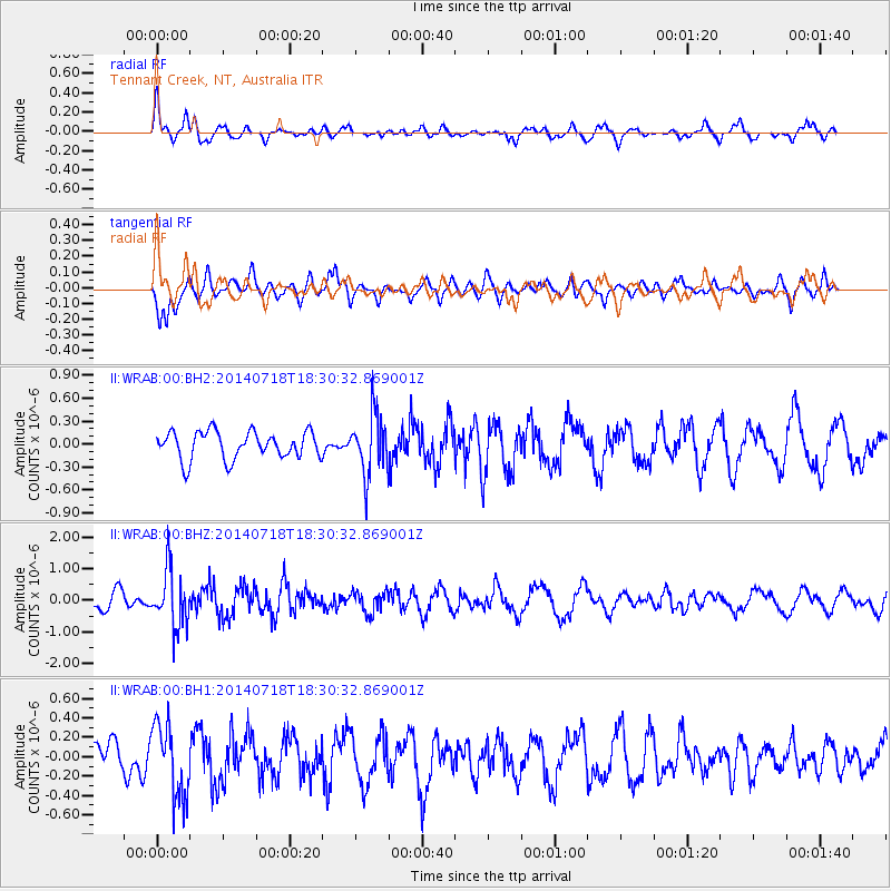
WRAB Tennant Creek, NT, Australia - Earthquake Result Viewer
*The percent match for this event was below the threshold and hence no stack was calculated.
| Earthquake location: |
South Of Kermadec Islands |
| Earthquake latitude/longitude: |
-34.6/-179.6 |
| Earthquake time(UTC): |
2014/07/18 (199) 18:23:06 GMT |
| Earthquake Depth: |
34 km |
| Earthquake Magnitude: |
5.6 MB |
| Earthquake Catalog/Contributor: |
NEIC PDE/NEIC COMCAT |
|
| Network: |
II Global Seismograph Network (GSN - IRIS/IDA) |
| Station: |
WRAB Tennant Creek, NT, Australia |
| Lat/Lon: |
19.93 S/134.36 E |
| Elevation: |
366 m |
|
| Distance: |
43.1 deg |
| Az: |
277.595 deg |
| Baz: |
119.7 deg |
| Ray Param: |
$rayparam |
*The percent match for this event was below the threshold and hence was not used in the summary stack. |
|
| Radial Match: |
65.800446 % |
| Radial Bump: |
400 |
| Transverse Match: |
58.654335 % |
| Transverse Bump: |
400 |
| SOD ConfigId: |
751272 |
| Insert Time: |
2014-08-01 19:11:01.092 +0000 |
| GWidth: |
2.5 |
| Max Bumps: |
400 |
| Tol: |
0.001 |
|
Signal To Noise
| Channel | StoN | STA | LTA |
| II:WRAB:00:BHZ:20140718T18:30:32.869001Z | 2.5406914 | 8.892694E-7 | 3.500108E-7 |
| II:WRAB:00:BH1:20140718T18:30:32.869001Z | 1.3878771 | 3.793521E-7 | 2.733326E-7 |
| II:WRAB:00:BH2:20140718T18:30:32.869001Z | 2.1971996 | 3.9545313E-7 | 1.7998053E-7 |
| Arrivals |
| Ps | |
| PpPs | |
| PsPs/PpSs | |


