You are here: Home > Network List > TA - USArray Transportable Network (new EarthScope stations) Stations List
> Station J05D Fort Rock, OR, USA > Earthquake Result Viewer
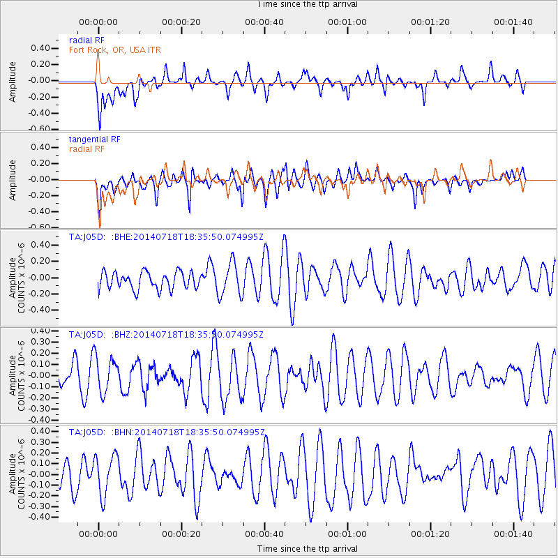
J05D Fort Rock, OR, USA - Earthquake Result Viewer
*The percent match for this event was below the threshold and hence no stack was calculated.
| Earthquake location: |
South Of Kermadec Islands |
| Earthquake latitude/longitude: |
-34.6/-179.6 |
| Earthquake time(UTC): |
2014/07/18 (199) 18:23:06 GMT |
| Earthquake Depth: |
34 km |
| Earthquake Magnitude: |
5.6 MB |
| Earthquake Catalog/Contributor: |
NEIC PDE/NEIC COMCAT |
|
| Network: |
TA USArray Transportable Network (new EarthScope stations) |
| Station: |
J05D Fort Rock, OR, USA |
| Lat/Lon: |
43.28 N/121.23 W |
| Elevation: |
1541 m |
|
| Distance: |
94.1 deg |
| Az: |
38.566 deg |
| Baz: |
224.735 deg |
| Ray Param: |
$rayparam |
*The percent match for this event was below the threshold and hence was not used in the summary stack. |
|
| Radial Match: |
47.12203 % |
| Radial Bump: |
400 |
| Transverse Match: |
52.939587 % |
| Transverse Bump: |
400 |
| SOD ConfigId: |
751272 |
| Insert Time: |
2014-08-01 19:16:58.553 +0000 |
| GWidth: |
2.5 |
| Max Bumps: |
400 |
| Tol: |
0.001 |
|
Signal To Noise
| Channel | StoN | STA | LTA |
| TA:J05D: :BHZ:20140718T18:35:50.074995Z | 1.268187 | 1.5359669E-7 | 1.2111516E-7 |
| TA:J05D: :BHN:20140718T18:35:50.074995Z | 1.566019 | 1.9536769E-7 | 1.2475435E-7 |
| TA:J05D: :BHE:20140718T18:35:50.074995Z | 2.0325322 | 2.0887275E-7 | 1.0276479E-7 |
| Arrivals |
| Ps | |
| PpPs | |
| PsPs/PpSs | |


