You are here: Home > Network List > US - United States National Seismic Network Stations List
> Station MNTX Cornudas Mountains, Texas, USA > Earthquake Result Viewer
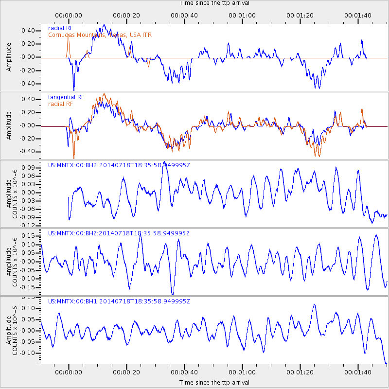
MNTX Cornudas Mountains, Texas, USA - Earthquake Result Viewer
*The percent match for this event was below the threshold and hence no stack was calculated.
| Earthquake location: |
South Of Kermadec Islands |
| Earthquake latitude/longitude: |
-34.6/-179.6 |
| Earthquake time(UTC): |
2014/07/18 (199) 18:23:06 GMT |
| Earthquake Depth: |
34 km |
| Earthquake Magnitude: |
5.6 MB |
| Earthquake Catalog/Contributor: |
NEIC PDE/NEIC COMCAT |
|
| Network: |
US United States National Seismic Network |
| Station: |
MNTX Cornudas Mountains, Texas, USA |
| Lat/Lon: |
31.70 N/105.38 W |
| Elevation: |
404 m |
|
| Distance: |
96.0 deg |
| Az: |
55.576 deg |
| Baz: |
232.924 deg |
| Ray Param: |
$rayparam |
*The percent match for this event was below the threshold and hence was not used in the summary stack. |
|
| Radial Match: |
22.142946 % |
| Radial Bump: |
400 |
| Transverse Match: |
25.529186 % |
| Transverse Bump: |
400 |
| SOD ConfigId: |
751272 |
| Insert Time: |
2014-08-01 19:18:00.475 +0000 |
| GWidth: |
2.5 |
| Max Bumps: |
400 |
| Tol: |
0.001 |
|
Signal To Noise
| Channel | StoN | STA | LTA |
| US:MNTX:00:BHZ:20140718T18:35:58.949995Z | 1.0565338 | 4.830218E-8 | 4.5717588E-8 |
| US:MNTX:00:BH1:20140718T18:35:58.949995Z | 0.5137801 | 2.024668E-8 | 3.9407286E-8 |
| US:MNTX:00:BH2:20140718T18:35:58.949995Z | 2.1800454 | 7.9001865E-8 | 3.623863E-8 |
| Arrivals |
| Ps | |
| PpPs | |
| PsPs/PpSs | |


