You are here: Home > Network List > CI - Caltech Regional Seismic Network Stations List
> Station NEE Needles, California, USA > Earthquake Result Viewer
NEE Needles, California, USA - Earthquake Result Viewer
| Earthquake location: |
Fiji Islands Region |
| Earthquake latitude/longitude: |
-21.6/-176.4 |
| Earthquake time(UTC): |
1998/12/27 (361) 00:38:26 GMT |
| Earthquake Depth: |
144 km |
| Earthquake Magnitude: |
6.1 MB, 6.9 UNKNOWN, 6.6 ME |
| Earthquake Catalog/Contributor: |
WHDF/NEIC |
|
| Network: |
CI Caltech Regional Seismic Network |
| Station: |
NEE Needles, California, USA |
| Lat/Lon: |
34.82 N/114.60 W |
| Elevation: |
139 m |
|
| Distance: |
81.2 deg |
| Az: |
47.189 deg |
| Baz: |
236.063 deg |
| Ray Param: |
0.04743738 |
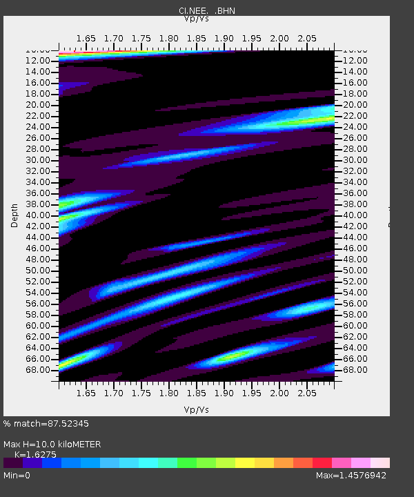
| Estimated Moho Depth: |
10.0 km |
| Estimated Crust Vp/Vs: |
1.63 |
| Assumed Crust Vp: |
6.276 km/s |
| Estimated Crust Vs: |
3.856 km/s |
| Estimated Crust Poisson's Ratio: |
0.20 |
|
| Radial Match: |
87.52345 % |
| Radial Bump: |
400 |
| Transverse Match: |
86.21387 % |
| Transverse Bump: |
400 |
| SOD ConfigId: |
3787 |
| Insert Time: |
2010-02-25 21:12:09.521 +0000 |
| GWidth: |
2.5 |
| Max Bumps: |
400 |
| Tol: |
0.001 |
|

Signal To Noise
| Channel | StoN | STA | LTA |
| CI:NEE: :BHN:19981227T00:49:55.165027Z | 1.5181848 | 2.9077654E-7 | 1.9152907E-7 |
| CI:NEE: :BHE:19981227T00:49:55.165027Z | 1.0163426 | 2.7656793E-7 | 2.7212076E-7 |
| CI:NEE: :BHZ:19981227T00:49:55.165027Z | 7.1236267 | 1.0672281E-6 | 1.4981528E-7 |
| Arrivals |
| Ps | 1.0 SECOND |
| PpPs | 4.1 SECOND |
| PsPs/PpSs | 5.1 SECOND |


