You are here: Home > Network List > AV - Alaska Volcano Observatory Stations List
> Station SPCR Ckakachatna River, Mount Spurr, Alaska > Earthquake Result Viewer
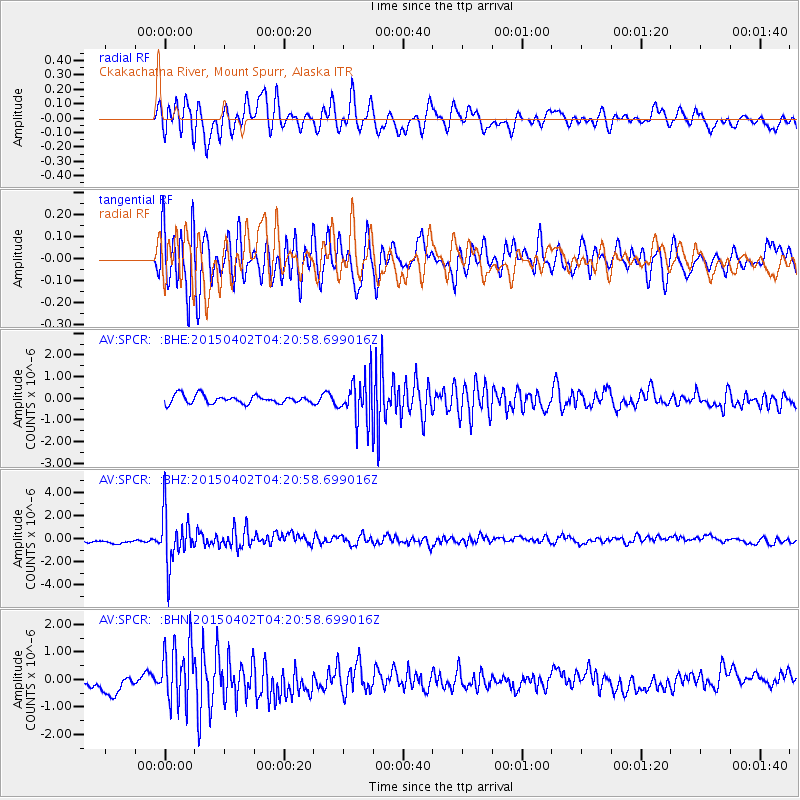
SPCR Ckakachatna River, Mount Spurr, Alaska - Earthquake Result Viewer
*The percent match for this event was below the threshold and hence no stack was calculated.
| Earthquake location: |
Fiji Islands Region |
| Earthquake latitude/longitude: |
-17.8/-178.7 |
| Earthquake time(UTC): |
2015/04/02 (092) 04:10:09 GMT |
| Earthquake Depth: |
536 km |
| Earthquake Magnitude: |
6.0 MWP |
| Earthquake Catalog/Contributor: |
NEIC PDE/NEIC COMCAT |
|
| Network: |
AV Alaska Volcano Observatory |
| Station: |
SPCR Ckakachatna River, Mount Spurr, Alaska |
| Lat/Lon: |
61.20 N/152.21 W |
| Elevation: |
984 m |
|
| Distance: |
81.5 deg |
| Az: |
12.599 deg |
| Baz: |
205.415 deg |
| Ray Param: |
$rayparam |
*The percent match for this event was below the threshold and hence was not used in the summary stack. |
|
| Radial Match: |
67.56521 % |
| Radial Bump: |
400 |
| Transverse Match: |
72.67215 % |
| Transverse Bump: |
400 |
| SOD ConfigId: |
7422571 |
| Insert Time: |
2019-04-18 01:18:47.433 +0000 |
| GWidth: |
2.5 |
| Max Bumps: |
400 |
| Tol: |
0.001 |
|
Signal To Noise
| Channel | StoN | STA | LTA |
| AV:SPCR: :BHZ:20150402T04:20:58.699016Z | 7.602621 | 2.1695844E-6 | 2.853732E-7 |
| AV:SPCR: :BHN:20150402T04:20:58.699016Z | 3.6472783 | 1.0718576E-6 | 2.9387877E-7 |
| AV:SPCR: :BHE:20150402T04:20:58.699016Z | 6.430687 | 1.1846013E-6 | 1.8421069E-7 |
| Arrivals |
| Ps | |
| PpPs | |
| PsPs/PpSs | |


