You are here: Home > Network List > AE - Arizona Broadband Seismic Network Stations List
> Station Y14A Wickenburg, AZ, USA > Earthquake Result Viewer
Y14A Wickenburg, AZ, USA - Earthquake Result Viewer
| Earthquake location: |
Tonga Islands |
| Earthquake latitude/longitude: |
-15.8/-174.4 |
| Earthquake time(UTC): |
2014/07/19 (200) 12:27:09 GMT |
| Earthquake Depth: |
220 km |
| Earthquake Magnitude: |
6.0 MWP |
| Earthquake Catalog/Contributor: |
NEIC PDE/NEIC COMCAT |
|
| Network: |
AE Arizona Broadband Seismic Network |
| Station: |
Y14A Wickenburg, AZ, USA |
| Lat/Lon: |
33.94 N/113.00 W |
| Elevation: |
731 m |
|
| Distance: |
76.5 deg |
| Az: |
48.637 deg |
| Baz: |
240.354 deg |
| Ray Param: |
0.050352428 |
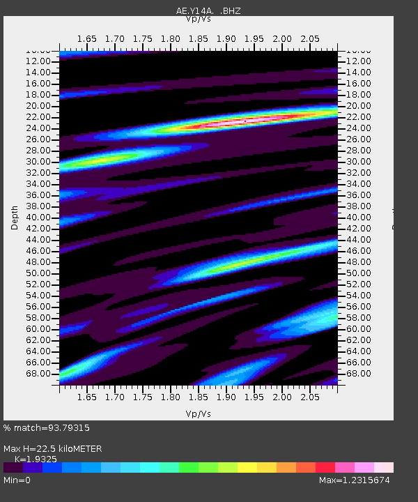
| Estimated Moho Depth: |
22.5 km |
| Estimated Crust Vp/Vs: |
1.93 |
| Assumed Crust Vp: |
6.264 km/s |
| Estimated Crust Vs: |
3.241 km/s |
| Estimated Crust Poisson's Ratio: |
0.32 |
|
| Radial Match: |
93.79315 % |
| Radial Bump: |
400 |
| Transverse Match: |
84.67217 % |
| Transverse Bump: |
400 |
| SOD ConfigId: |
751272 |
| Insert Time: |
2014-08-02 12:47:42.187 +0000 |
| GWidth: |
2.5 |
| Max Bumps: |
400 |
| Tol: |
0.001 |
|

Signal To Noise
| Channel | StoN | STA | LTA |
| AE:Y14A: :BHZ:20140719T12:38:03.975017Z | 27.008339 | 9.668955E-7 | 3.579989E-8 |
| AE:Y14A: :BHN:20140719T12:38:03.975017Z | 7.593223 | 2.4155426E-7 | 3.1811826E-8 |
| AE:Y14A: :BHE:20140719T12:38:03.975017Z | 8.72387 | 3.473773E-7 | 3.9819174E-8 |
| Arrivals |
| Ps | 3.4 SECOND |
| PpPs | 10 SECOND |
| PsPs/PpSs | 14 SECOND |


