You are here: Home > Network List > CI - Caltech Regional Seismic Network Stations List
> Station NEE Needles, California, USA > Earthquake Result Viewer
NEE Needles, California, USA - Earthquake Result Viewer
| Earthquake location: |
South Of Panama |
| Earthquake latitude/longitude: |
7.7/-82.8 |
| Earthquake time(UTC): |
1998/11/17 (321) 03:57:58 GMT |
| Earthquake Depth: |
17 km |
| Earthquake Magnitude: |
5.2 MB, 5.5 MS, 5.9 UNKNOWN, 5.8 MW |
| Earthquake Catalog/Contributor: |
WHDF/NEIC |
|
| Network: |
CI Caltech Regional Seismic Network |
| Station: |
NEE Needles, California, USA |
| Lat/Lon: |
34.82 N/114.60 W |
| Elevation: |
139 m |
|
| Distance: |
39.8 deg |
| Az: |
317.347 deg |
| Baz: |
125.282 deg |
| Ray Param: |
0.074751504 |
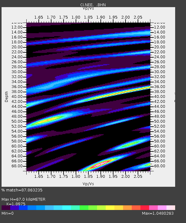
| Estimated Moho Depth: |
67.0 km |
| Estimated Crust Vp/Vs: |
1.90 |
| Assumed Crust Vp: |
6.276 km/s |
| Estimated Crust Vs: |
3.307 km/s |
| Estimated Crust Poisson's Ratio: |
0.31 |
|
| Radial Match: |
87.863235 % |
| Radial Bump: |
400 |
| Transverse Match: |
67.6753 % |
| Transverse Bump: |
400 |
| SOD ConfigId: |
3770 |
| Insert Time: |
2010-02-25 21:12:10.847 +0000 |
| GWidth: |
2.5 |
| Max Bumps: |
400 |
| Tol: |
0.001 |
|

Signal To Noise
| Channel | StoN | STA | LTA |
| CI:NEE: :BHN:19981117T04:05:00.234015Z | 0.9316221 | 3.4067426E-7 | 3.6567863E-7 |
| CI:NEE: :BHE:19981117T04:05:00.234015Z | 0.8494595 | 4.356819E-7 | 5.128931E-7 |
| CI:NEE: :BHZ:19981117T04:05:00.234015Z | 1.1132313 | 4.769612E-7 | 4.284475E-7 |
| Arrivals |
| Ps | 10 SECOND |
| PpPs | 29 SECOND |
| PsPs/PpSs | 39 SECOND |


