You are here: Home > Network List > AK - Alaska Regional Network Stations List
> Station WAT5 Susitna Watana 5, AK, USA > Earthquake Result Viewer
WAT5 Susitna Watana 5, AK, USA - Earthquake Result Viewer
| Earthquake location: |
Tonga Islands |
| Earthquake latitude/longitude: |
-15.8/-174.4 |
| Earthquake time(UTC): |
2014/07/19 (200) 12:27:09 GMT |
| Earthquake Depth: |
220 km |
| Earthquake Magnitude: |
6.0 MWP |
| Earthquake Catalog/Contributor: |
NEIC PDE/NEIC COMCAT |
|
| Network: |
AK Alaska Regional Network |
| Station: |
WAT5 Susitna Watana 5, AK, USA |
| Lat/Lon: |
63.06 N/148.23 W |
| Elevation: |
1691 m |
|
| Distance: |
81.2 deg |
| Az: |
11.729 deg |
| Baz: |
205.449 deg |
| Ray Param: |
0.047182593 |
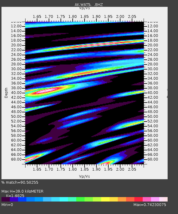
| Estimated Moho Depth: |
39.0 km |
| Estimated Crust Vp/Vs: |
1.68 |
| Assumed Crust Vp: |
6.566 km/s |
| Estimated Crust Vs: |
3.903 km/s |
| Estimated Crust Poisson's Ratio: |
0.23 |
|
| Radial Match: |
90.58255 % |
| Radial Bump: |
400 |
| Transverse Match: |
86.32365 % |
| Transverse Bump: |
400 |
| SOD ConfigId: |
751272 |
| Insert Time: |
2014-08-02 12:53:10.646 +0000 |
| GWidth: |
2.5 |
| Max Bumps: |
400 |
| Tol: |
0.001 |
|

Signal To Noise
| Channel | StoN | STA | LTA |
| AK:WAT5: :BHZ:20140719T12:38:29.308025Z | 9.146397 | 4.0793512E-7 | 4.460064E-8 |
| AK:WAT5: :BHN:20140719T12:38:29.308025Z | 3.4001384 | 1.8429822E-7 | 5.4203152E-8 |
| AK:WAT5: :BHE:20140719T12:38:29.308025Z | 2.3776684 | 1.6759918E-7 | 7.048888E-8 |
| Arrivals |
| Ps | 4.2 SECOND |
| PpPs | 15 SECOND |
| PsPs/PpSs | 20 SECOND |


