You are here: Home > Network List > AU - Australian Seismological Centre Stations List
> Station WRKA Warrakurna, Western Australia > Earthquake Result Viewer
WRKA Warrakurna, Western Australia - Earthquake Result Viewer
| Earthquake location: |
Tonga Islands |
| Earthquake latitude/longitude: |
-15.8/-174.4 |
| Earthquake time(UTC): |
2014/07/19 (200) 12:27:09 GMT |
| Earthquake Depth: |
220 km |
| Earthquake Magnitude: |
6.0 MWP |
| Earthquake Catalog/Contributor: |
NEIC PDE/NEIC COMCAT |
|
| Network: |
AU Australian Seismological Centre |
| Station: |
WRKA Warrakurna, Western Australia |
| Lat/Lon: |
25.04 S/128.30 E |
| Elevation: |
622 m |
|
| Distance: |
54.1 deg |
| Az: |
250.349 deg |
| Baz: |
91.877 deg |
| Ray Param: |
0.06486221 |
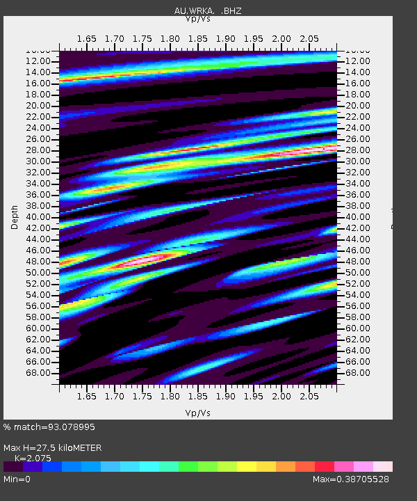
| Estimated Moho Depth: |
27.5 km |
| Estimated Crust Vp/Vs: |
2.08 |
| Assumed Crust Vp: |
6.51 km/s |
| Estimated Crust Vs: |
3.137 km/s |
| Estimated Crust Poisson's Ratio: |
0.35 |
|
| Radial Match: |
93.078995 % |
| Radial Bump: |
400 |
| Transverse Match: |
75.0778 % |
| Transverse Bump: |
400 |
| SOD ConfigId: |
751272 |
| Insert Time: |
2014-08-02 12:57:11.790 +0000 |
| GWidth: |
2.5 |
| Max Bumps: |
400 |
| Tol: |
0.001 |
|

Signal To Noise
| Channel | StoN | STA | LTA |
| AU:WRKA: :BHZ:20140719T12:35:40.918987Z | 19.10589 | 6.691782E-6 | 3.5024703E-7 |
| AU:WRKA: :BHN:20140719T12:35:40.918987Z | 2.4667742 | 4.5020215E-7 | 1.8250641E-7 |
| AU:WRKA: :BHE:20140719T12:35:40.918987Z | 17.553019 | 3.3148067E-6 | 1.8884539E-7 |
| Arrivals |
| Ps | 4.8 SECOND |
| PpPs | 12 SECOND |
| PsPs/PpSs | 17 SECOND |


