You are here: Home > Network List > BK - Berkeley Digital Seismograph Network Stations List
> Station WDC Whiskeytown, CA > Earthquake Result Viewer
WDC Whiskeytown, CA - Earthquake Result Viewer
| Earthquake location: |
Tonga Islands |
| Earthquake latitude/longitude: |
-15.8/-174.4 |
| Earthquake time(UTC): |
2014/07/19 (200) 12:27:09 GMT |
| Earthquake Depth: |
220 km |
| Earthquake Magnitude: |
6.0 MWP |
| Earthquake Catalog/Contributor: |
NEIC PDE/NEIC COMCAT |
|
| Network: |
BK Berkeley Digital Seismograph Network |
| Station: |
WDC Whiskeytown, CA |
| Lat/Lon: |
40.58 N/122.54 W |
| Elevation: |
268 m |
|
| Distance: |
73.9 deg |
| Az: |
38.576 deg |
| Baz: |
232.013 deg |
| Ray Param: |
0.052103195 |
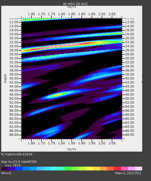
| Estimated Moho Depth: |
23.5 km |
| Estimated Crust Vp/Vs: |
1.80 |
| Assumed Crust Vp: |
6.566 km/s |
| Estimated Crust Vs: |
3.653 km/s |
| Estimated Crust Poisson's Ratio: |
0.28 |
|
| Radial Match: |
86.82834 % |
| Radial Bump: |
299 |
| Transverse Match: |
76.12094 % |
| Transverse Bump: |
365 |
| SOD ConfigId: |
751272 |
| Insert Time: |
2014-08-02 13:00:09.561 +0000 |
| GWidth: |
2.5 |
| Max Bumps: |
400 |
| Tol: |
0.001 |
|
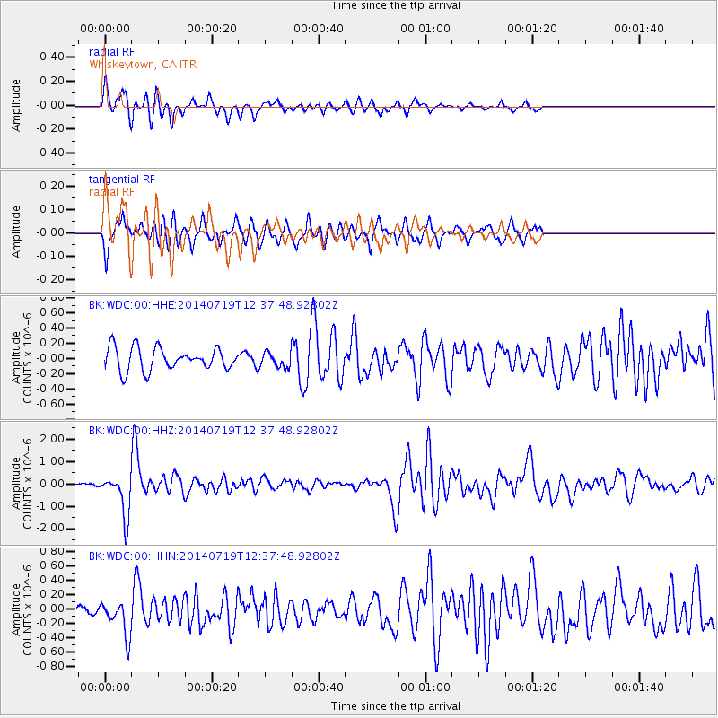
Signal To Noise
| Channel | StoN | STA | LTA |
| BK:WDC:00:HHZ:20140719T12:37:48.92802Z | 11.265373 | 9.595075E-7 | 8.517316E-8 |
| BK:WDC:00:HHN:20140719T12:37:48.92802Z | 2.1514034 | 2.4290676E-7 | 1.1290619E-7 |
| BK:WDC:00:HHE:20140719T12:37:48.92802Z | 0.6450714 | 9.609486E-8 | 1.4896779E-7 |
| Arrivals |
| Ps | 3.0 SECOND |
| PpPs | 9.7 SECOND |
| PsPs/PpSs | 13 SECOND |


