You are here: Home > Network List > CC - Cascade Chain Volcano Monitoring Stations List
> Station TCBU Trout Creek Butte at 3-Sisters, OR > Earthquake Result Viewer
TCBU Trout Creek Butte at 3-Sisters, OR - Earthquake Result Viewer
| Earthquake location: |
Tonga Islands |
| Earthquake latitude/longitude: |
-15.8/-174.4 |
| Earthquake time(UTC): |
2014/07/19 (200) 12:27:09 GMT |
| Earthquake Depth: |
220 km |
| Earthquake Magnitude: |
6.0 MWP |
| Earthquake Catalog/Contributor: |
NEIC PDE/NEIC COMCAT |
|
| Network: |
CC Cascade Chain Volcano Monitoring |
| Station: |
TCBU Trout Creek Butte at 3-Sisters, OR |
| Lat/Lon: |
44.24 N/121.66 W |
| Elevation: |
1646 m |
|
| Distance: |
76.7 deg |
| Az: |
36.01 deg |
| Baz: |
231.95 deg |
| Ray Param: |
0.05027476 |
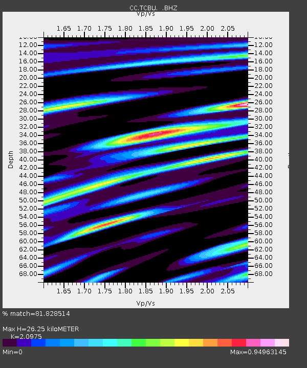
| Estimated Moho Depth: |
26.25 km |
| Estimated Crust Vp/Vs: |
2.10 |
| Assumed Crust Vp: |
6.597 km/s |
| Estimated Crust Vs: |
3.145 km/s |
| Estimated Crust Poisson's Ratio: |
0.35 |
|
| Radial Match: |
81.828514 % |
| Radial Bump: |
400 |
| Transverse Match: |
72.549126 % |
| Transverse Bump: |
400 |
| SOD ConfigId: |
751272 |
| Insert Time: |
2014-08-02 13:01:00.921 +0000 |
| GWidth: |
2.5 |
| Max Bumps: |
400 |
| Tol: |
0.001 |
|

Signal To Noise
| Channel | StoN | STA | LTA |
| CC:TCBU: :BHZ:20140719T12:38:04.619976Z | 4.5159516 | 6.418618E-7 | 1.4213212E-7 |
| CC:TCBU: :BHN:20140719T12:38:04.619976Z | 1.5607 | 3.2025648E-7 | 2.0520054E-7 |
| CC:TCBU: :BHE:20140719T12:38:04.619976Z | 1.1340425 | 2.5729756E-7 | 2.2688529E-7 |
| Arrivals |
| Ps | 4.5 SECOND |
| PpPs | 12 SECOND |
| PsPs/PpSs | 16 SECOND |


