You are here: Home > Network List > IW - Intermountain West Stations List
> Station DLMT Dillon, Montana, USA > Earthquake Result Viewer
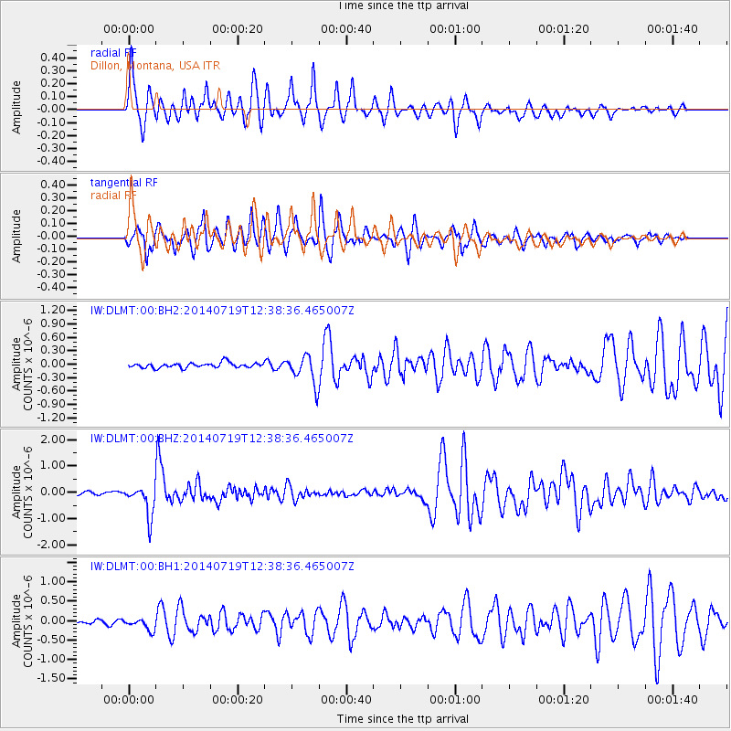
DLMT Dillon, Montana, USA - Earthquake Result Viewer

| Earthquake location: |
Tonga Islands |
| Earthquake latitude/longitude: |
-15.8/-174.4 |
| Earthquake time(UTC): |
2014/07/19 (200) 12:27:09 GMT |
| Earthquake Depth: |
220 km |
| Earthquake Magnitude: |
6.0 MWP |
| Earthquake Catalog/Contributor: |
NEIC PDE/NEIC COMCAT |
|
| Network: |
IW Intermountain West |
| Station: |
DLMT Dillon, Montana, USA |
| Lat/Lon: |
45.36 N/112.60 W |
| Elevation: |
1569 m |
|
| Distance: |
82.6 deg |
| Az: |
38.799 deg |
| Baz: |
238.828 deg |
| Ray Param: |
0.046233345 |
| Estimated Moho Depth: |
43.25 km |
| Estimated Crust Vp/Vs: |
1.88 |
| Assumed Crust Vp: |
6.577 km/s |
| Estimated Crust Vs: |
3.494 km/s |
| Estimated Crust Poisson's Ratio: |
0.30 |
|
| Radial Match: |
91.08035 % |
| Radial Bump: |
400 |
| Transverse Match: |
89.81304 % |
| Transverse Bump: |
400 |
| SOD ConfigId: |
751272 |
| Insert Time: |
2014-08-02 13:10:55.530 +0000 |
| GWidth: |
2.5 |
| Max Bumps: |
400 |
| Tol: |
0.001 |
|
Signal To Noise
| Channel | StoN | STA | LTA |
| IW:DLMT:00:BHZ:20140719T12:38:36.465007Z | 11.028362 | 5.952205E-7 | 5.3971796E-8 |
| IW:DLMT:00:BH1:20140719T12:38:36.465007Z | 2.162967 | 1.525422E-7 | 7.0524514E-8 |
| IW:DLMT:00:BH2:20140719T12:38:36.465007Z | 5.8028545 | 3.2204153E-7 | 5.549709E-8 |
| Arrivals |
| Ps | 6.0 SECOND |
| PpPs | 18 SECOND |
| PsPs/PpSs | 24 SECOND |


