You are here: Home > Network List > CI - Caltech Regional Seismic Network Stations List
> Station NEE Needles, California, USA > Earthquake Result Viewer
NEE Needles, California, USA - Earthquake Result Viewer
| Earthquake location: |
Easter Island Region |
| Earthquake latitude/longitude: |
-26.8/-113.3 |
| Earthquake time(UTC): |
1998/11/17 (321) 03:16:08 GMT |
| Earthquake Depth: |
10 km |
| Earthquake Magnitude: |
5.4 MB, 5.5 MS |
| Earthquake Catalog/Contributor: |
WHDF/NEIC |
|
| Network: |
CI Caltech Regional Seismic Network |
| Station: |
NEE Needles, California, USA |
| Lat/Lon: |
34.82 N/114.60 W |
| Elevation: |
139 m |
|
| Distance: |
61.3 deg |
| Az: |
358.772 deg |
| Baz: |
178.666 deg |
| Ray Param: |
0.06094103 |
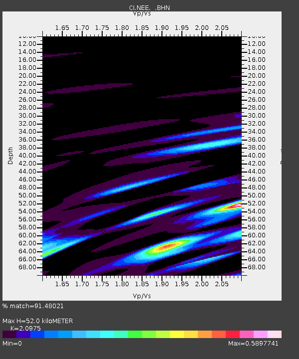
| Estimated Moho Depth: |
52.0 km |
| Estimated Crust Vp/Vs: |
2.10 |
| Assumed Crust Vp: |
6.276 km/s |
| Estimated Crust Vs: |
2.992 km/s |
| Estimated Crust Poisson's Ratio: |
0.35 |
|
| Radial Match: |
91.48021 % |
| Radial Bump: |
299 |
| Transverse Match: |
61.373867 % |
| Transverse Bump: |
400 |
| SOD ConfigId: |
3770 |
| Insert Time: |
2010-02-25 21:12:12.046 +0000 |
| GWidth: |
2.5 |
| Max Bumps: |
400 |
| Tol: |
0.001 |
|

Signal To Noise
| Channel | StoN | STA | LTA |
| CI:NEE: :BHN:19981117T03:25:53.33501Z | 0.7391862 | 3.983085E-7 | 5.3884725E-7 |
| CI:NEE: :BHE:19981117T03:25:53.33501Z | 0.5996849 | 4.7001674E-7 | 7.8377286E-7 |
| CI:NEE: :BHZ:19981117T03:25:53.33501Z | 0.83859164 | 4.4368005E-7 | 5.290776E-7 |
| Arrivals |
| Ps | 9.4 SECOND |
| PpPs | 25 SECOND |
| PsPs/PpSs | 34 SECOND |


