You are here: Home > Network List > TA - USArray Transportable Network (new EarthScope stations) Stations List
> Station A04D Lummi Island, WA, USA > Earthquake Result Viewer
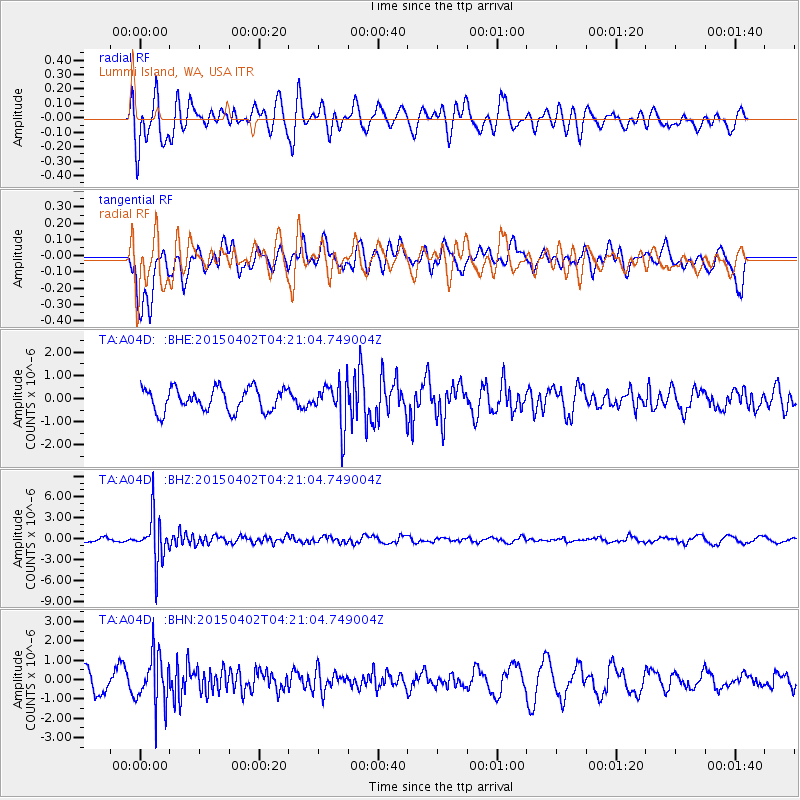
A04D Lummi Island, WA, USA - Earthquake Result Viewer
*The percent match for this event was below the threshold and hence no stack was calculated.
| Earthquake location: |
Fiji Islands Region |
| Earthquake latitude/longitude: |
-17.8/-178.7 |
| Earthquake time(UTC): |
2015/04/02 (092) 04:10:09 GMT |
| Earthquake Depth: |
536 km |
| Earthquake Magnitude: |
6.0 MWP |
| Earthquake Catalog/Contributor: |
NEIC PDE/NEIC COMCAT |
|
| Network: |
TA USArray Transportable Network (new EarthScope stations) |
| Station: |
A04D Lummi Island, WA, USA |
| Lat/Lon: |
48.72 N/122.71 W |
| Elevation: |
13 m |
|
| Distance: |
82.8 deg |
| Az: |
33.583 deg |
| Baz: |
232.73 deg |
| Ray Param: |
$rayparam |
*The percent match for this event was below the threshold and hence was not used in the summary stack. |
|
| Radial Match: |
69.60988 % |
| Radial Bump: |
400 |
| Transverse Match: |
63.366417 % |
| Transverse Bump: |
364 |
| SOD ConfigId: |
7422571 |
| Insert Time: |
2019-04-18 01:23:24.090 +0000 |
| GWidth: |
2.5 |
| Max Bumps: |
400 |
| Tol: |
0.001 |
|
Signal To Noise
| Channel | StoN | STA | LTA |
| TA:A04D: :BHZ:20150402T04:21:04.749004Z | 15.699282 | 3.3361978E-6 | 2.125064E-7 |
| TA:A04D: :BHN:20150402T04:21:04.749004Z | 3.0747628 | 1.3288186E-6 | 4.3216946E-7 |
| TA:A04D: :BHE:20150402T04:21:04.749004Z | 2.141386 | 1.0314741E-6 | 4.816853E-7 |
| Arrivals |
| Ps | |
| PpPs | |
| PsPs/PpSs | |


