You are here: Home > Network List > OK - Oklahoma Seismic Network Stations List
> Station FNO Franklin, Norman, OK > Earthquake Result Viewer
FNO Franklin, Norman, OK - Earthquake Result Viewer
| Earthquake location: |
Tonga Islands |
| Earthquake latitude/longitude: |
-15.8/-174.4 |
| Earthquake time(UTC): |
2014/07/19 (200) 12:27:09 GMT |
| Earthquake Depth: |
220 km |
| Earthquake Magnitude: |
6.0 MWP |
| Earthquake Catalog/Contributor: |
NEIC PDE/NEIC COMCAT |
|
| Network: |
OK Oklahoma Seismic Network |
| Station: |
FNO Franklin, Norman, OK |
| Lat/Lon: |
35.26 N/97.40 W |
| Elevation: |
360 m |
|
| Distance: |
88.8 deg |
| Az: |
52.903 deg |
| Baz: |
249.761 deg |
| Ray Param: |
0.041844685 |
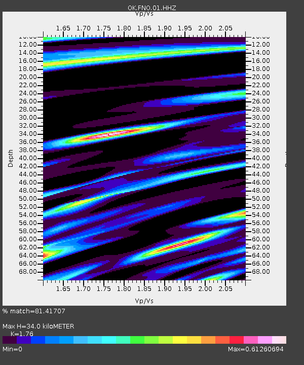
| Estimated Moho Depth: |
34.0 km |
| Estimated Crust Vp/Vs: |
1.76 |
| Assumed Crust Vp: |
6.426 km/s |
| Estimated Crust Vs: |
3.651 km/s |
| Estimated Crust Poisson's Ratio: |
0.26 |
|
| Radial Match: |
81.41707 % |
| Radial Bump: |
400 |
| Transverse Match: |
63.746326 % |
| Transverse Bump: |
400 |
| SOD ConfigId: |
751272 |
| Insert Time: |
2014-08-02 13:18:43.095 +0000 |
| GWidth: |
2.5 |
| Max Bumps: |
400 |
| Tol: |
0.001 |
|

Signal To Noise
| Channel | StoN | STA | LTA |
| OK:FNO:01:HHZ:20140719T12:39:06.559001Z | 6.711949 | 6.2824313E-7 | 9.36007E-8 |
| OK:FNO:01:HHN:20140719T12:39:06.559001Z | 0.2544257 | 7.609694E-8 | 2.99093E-7 |
| OK:FNO:01:HHE:20140719T12:39:06.559001Z | 2.314483 | 2.6635638E-7 | 1.1508245E-7 |
| Arrivals |
| Ps | 4.1 SECOND |
| PpPs | 14 SECOND |
| PsPs/PpSs | 18 SECOND |


