You are here: Home > Network List > TA - USArray Transportable Network (new EarthScope stations) Stations List
> Station MDND Maddock, ND, USA > Earthquake Result Viewer
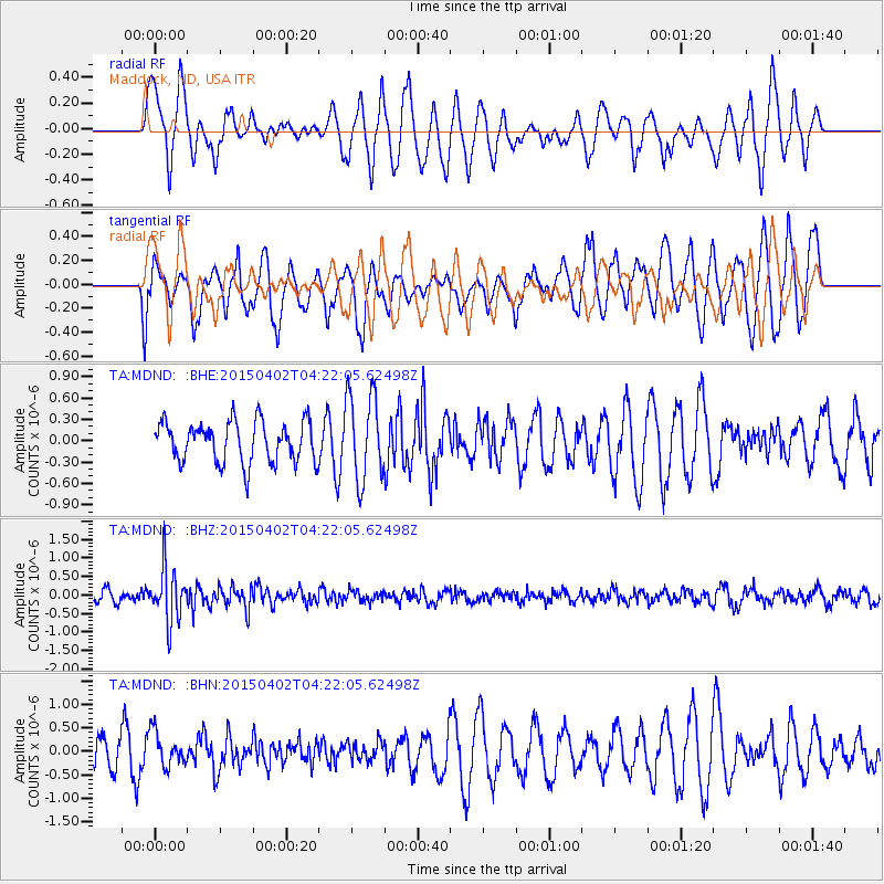
MDND Maddock, ND, USA - Earthquake Result Viewer
*The percent match for this event was below the threshold and hence no stack was calculated.
| Earthquake location: |
Fiji Islands Region |
| Earthquake latitude/longitude: |
-17.8/-178.7 |
| Earthquake time(UTC): |
2015/04/02 (092) 04:10:09 GMT |
| Earthquake Depth: |
536 km |
| Earthquake Magnitude: |
6.0 MWP |
| Earthquake Catalog/Contributor: |
NEIC PDE/NEIC COMCAT |
|
| Network: |
TA USArray Transportable Network (new EarthScope stations) |
| Station: |
MDND Maddock, ND, USA |
| Lat/Lon: |
47.85 N/99.60 W |
| Elevation: |
479 m |
|
| Distance: |
95.9 deg |
| Az: |
41.672 deg |
| Baz: |
250.121 deg |
| Ray Param: |
$rayparam |
*The percent match for this event was below the threshold and hence was not used in the summary stack. |
|
| Radial Match: |
64.16592 % |
| Radial Bump: |
339 |
| Transverse Match: |
50.505054 % |
| Transverse Bump: |
373 |
| SOD ConfigId: |
7422571 |
| Insert Time: |
2019-04-18 01:23:50.031 +0000 |
| GWidth: |
2.5 |
| Max Bumps: |
400 |
| Tol: |
0.001 |
|
Signal To Noise
| Channel | StoN | STA | LTA |
| TA:MDND: :BHZ:20150402T04:22:05.62498Z | 4.4778113 | 7.2027245E-7 | 1.6085369E-7 |
| TA:MDND: :BHN:20150402T04:22:05.62498Z | 0.85798544 | 3.658796E-7 | 4.2644035E-7 |
| TA:MDND: :BHE:20150402T04:22:05.62498Z | 1.8821285 | 5.4669204E-7 | 2.9046478E-7 |
| Arrivals |
| Ps | |
| PpPs | |
| PsPs/PpSs | |


