You are here: Home > Network List > TA - USArray Transportable Network (new EarthScope stations) Stations List
> Station O03E Paynes Creek, CA, USA > Earthquake Result Viewer
O03E Paynes Creek, CA, USA - Earthquake Result Viewer
| Earthquake location: |
Tonga Islands |
| Earthquake latitude/longitude: |
-15.8/-174.4 |
| Earthquake time(UTC): |
2014/07/19 (200) 12:27:09 GMT |
| Earthquake Depth: |
220 km |
| Earthquake Magnitude: |
6.0 MWP |
| Earthquake Catalog/Contributor: |
NEIC PDE/NEIC COMCAT |
|
| Network: |
TA USArray Transportable Network (new EarthScope stations) |
| Station: |
O03E Paynes Creek, CA, USA |
| Lat/Lon: |
40.29 N/121.80 W |
| Elevation: |
967 m |
|
| Distance: |
74.2 deg |
| Az: |
39.169 deg |
| Baz: |
232.654 deg |
| Ray Param: |
0.051925074 |
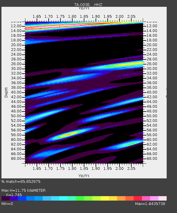
| Estimated Moho Depth: |
11.75 km |
| Estimated Crust Vp/Vs: |
1.75 |
| Assumed Crust Vp: |
6.566 km/s |
| Estimated Crust Vs: |
3.763 km/s |
| Estimated Crust Poisson's Ratio: |
0.26 |
|
| Radial Match: |
85.852875 % |
| Radial Bump: |
310 |
| Transverse Match: |
86.35473 % |
| Transverse Bump: |
392 |
| SOD ConfigId: |
751272 |
| Insert Time: |
2014-08-02 13:26:41.506 +0000 |
| GWidth: |
2.5 |
| Max Bumps: |
400 |
| Tol: |
0.001 |
|
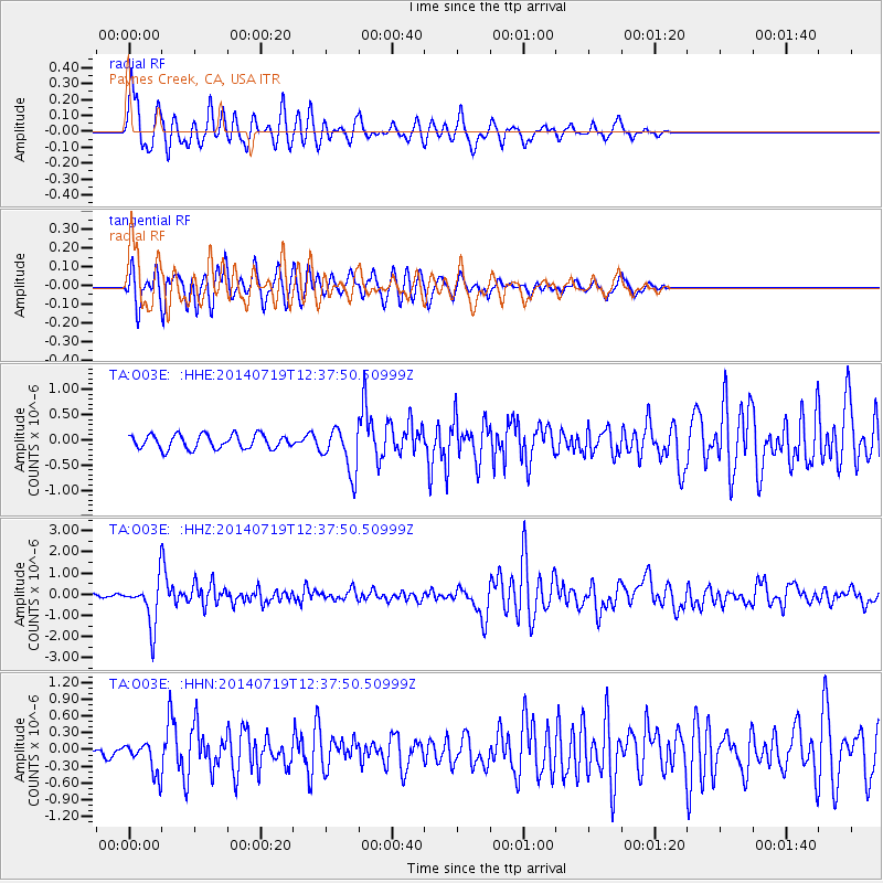
Signal To Noise
| Channel | StoN | STA | LTA |
| TA:O03E: :HHZ:20140719T12:37:50.50999Z | 15.812113 | 1.0640638E-6 | 6.729422E-8 |
| TA:O03E: :HHN:20140719T12:37:50.50999Z | 2.3982198 | 2.6829505E-7 | 1.1187259E-7 |
| TA:O03E: :HHE:20140719T12:37:50.50999Z | 3.1826403 | 4.4423334E-7 | 1.3958012E-7 |
| Arrivals |
| Ps | 1.4 SECOND |
| PpPs | 4.7 SECOND |
| PsPs/PpSs | 6.1 SECOND |


