You are here: Home > Network List > TA - USArray Transportable Network (new EarthScope stations) Stations List
> Station U40A Yellville, AR, USA > Earthquake Result Viewer
U40A Yellville, AR, USA - Earthquake Result Viewer
| Earthquake location: |
Tonga Islands |
| Earthquake latitude/longitude: |
-15.8/-174.4 |
| Earthquake time(UTC): |
2014/07/19 (200) 12:27:09 GMT |
| Earthquake Depth: |
220 km |
| Earthquake Magnitude: |
6.0 MWP |
| Earthquake Catalog/Contributor: |
NEIC PDE/NEIC COMCAT |
|
| Network: |
TA USArray Transportable Network (new EarthScope stations) |
| Station: |
U40A Yellville, AR, USA |
| Lat/Lon: |
36.36 N/92.85 W |
| Elevation: |
374 m |
|
| Distance: |
92.6 deg |
| Az: |
53.064 deg |
| Baz: |
252.409 deg |
| Ray Param: |
0.041290574 |
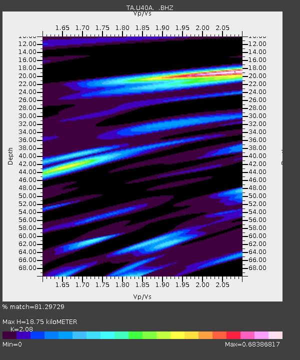
| Estimated Moho Depth: |
18.75 km |
| Estimated Crust Vp/Vs: |
2.08 |
| Assumed Crust Vp: |
6.53 km/s |
| Estimated Crust Vs: |
3.14 km/s |
| Estimated Crust Poisson's Ratio: |
0.35 |
|
| Radial Match: |
81.29729 % |
| Radial Bump: |
333 |
| Transverse Match: |
58.52974 % |
| Transverse Bump: |
379 |
| SOD ConfigId: |
751272 |
| Insert Time: |
2014-08-02 13:27:24.299 +0000 |
| GWidth: |
2.5 |
| Max Bumps: |
400 |
| Tol: |
0.001 |
|

Signal To Noise
| Channel | StoN | STA | LTA |
| TA:U40A: :BHZ:20140719T12:39:24.350017Z | 10.590008 | 3.3370583E-7 | 3.1511387E-8 |
| TA:U40A: :BHN:20140719T12:39:24.350017Z | 1.5162394 | 6.402042E-8 | 4.222316E-8 |
| TA:U40A: :BHE:20140719T12:39:24.350017Z | 3.731235 | 1.3497943E-7 | 3.6175535E-8 |
| Arrivals |
| Ps | 3.2 SECOND |
| PpPs | 8.7 SECOND |
| PsPs/PpSs | 12 SECOND |


