You are here: Home > Network List > UU - University of Utah Regional Network Stations List
> Station HVU Hansel Valley, UT, USA > Earthquake Result Viewer
HVU Hansel Valley, UT, USA - Earthquake Result Viewer
| Earthquake location: |
Tonga Islands |
| Earthquake latitude/longitude: |
-15.8/-174.4 |
| Earthquake time(UTC): |
2014/07/19 (200) 12:27:09 GMT |
| Earthquake Depth: |
220 km |
| Earthquake Magnitude: |
6.0 MWP |
| Earthquake Catalog/Contributor: |
NEIC PDE/NEIC COMCAT |
|
| Network: |
UU University of Utah Regional Network |
| Station: |
HVU Hansel Valley, UT, USA |
| Lat/Lon: |
41.78 N/112.78 W |
| Elevation: |
1609 m |
|
| Distance: |
80.6 deg |
| Az: |
41.833 deg |
| Baz: |
239.147 deg |
| Ray Param: |
0.04758216 |
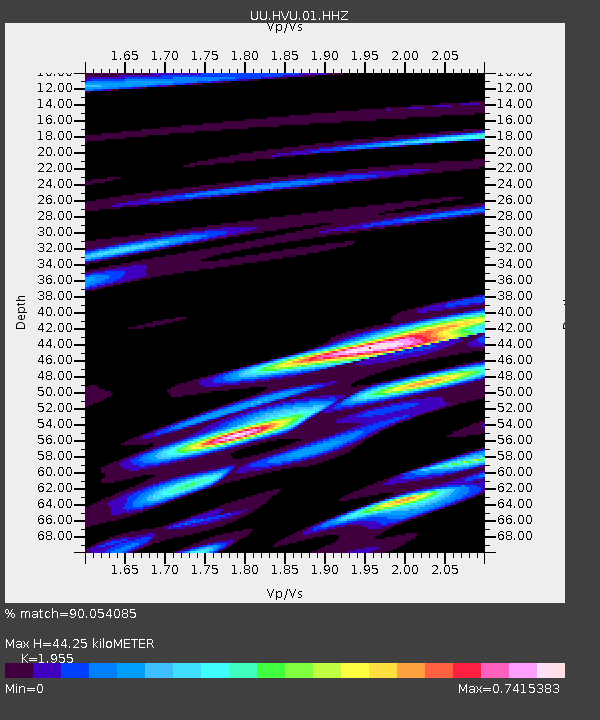
| Estimated Moho Depth: |
44.25 km |
| Estimated Crust Vp/Vs: |
1.96 |
| Assumed Crust Vp: |
6.276 km/s |
| Estimated Crust Vs: |
3.21 km/s |
| Estimated Crust Poisson's Ratio: |
0.32 |
|
| Radial Match: |
90.054085 % |
| Radial Bump: |
313 |
| Transverse Match: |
87.640724 % |
| Transverse Bump: |
392 |
| SOD ConfigId: |
751272 |
| Insert Time: |
2014-08-02 13:31:49.984 +0000 |
| GWidth: |
2.5 |
| Max Bumps: |
400 |
| Tol: |
0.001 |
|
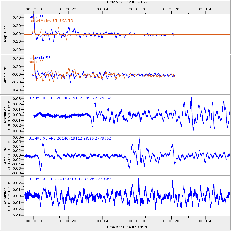
Signal To Noise
| Channel | StoN | STA | LTA |
| UU:HVU:01:HHZ:20140719T12:38:26.277996Z | 9.157836 | 2.6272327E-8 | 2.8688358E-9 |
| UU:HVU:01:HHN:20140719T12:38:26.277996Z | 1.3709745 | 4.516632E-9 | 3.2944683E-9 |
| UU:HVU:01:HHE:20140719T12:38:26.277996Z | 3.891493 | 7.871093E-9 | 2.022641E-9 |
| Arrivals |
| Ps | 6.9 SECOND |
| PpPs | 20 SECOND |
| PsPs/PpSs | 27 SECOND |


