You are here: Home > Network List > UU - University of Utah Regional Network Stations List
> Station KNB Kanab, UT, USA > Earthquake Result Viewer
KNB Kanab, UT, USA - Earthquake Result Viewer
| Earthquake location: |
Tonga Islands |
| Earthquake latitude/longitude: |
-15.8/-174.4 |
| Earthquake time(UTC): |
2014/07/19 (200) 12:27:09 GMT |
| Earthquake Depth: |
220 km |
| Earthquake Magnitude: |
6.0 MWP |
| Earthquake Catalog/Contributor: |
NEIC PDE/NEIC COMCAT |
|
| Network: |
UU University of Utah Regional Network |
| Station: |
KNB Kanab, UT, USA |
| Lat/Lon: |
37.02 N/112.82 W |
| Elevation: |
1715 m |
|
| Distance: |
78.2 deg |
| Az: |
45.984 deg |
| Baz: |
239.88 deg |
| Ray Param: |
0.04923939 |
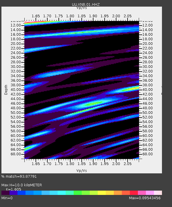
| Estimated Moho Depth: |
10.0 km |
| Estimated Crust Vp/Vs: |
1.61 |
| Assumed Crust Vp: |
6.194 km/s |
| Estimated Crust Vs: |
3.859 km/s |
| Estimated Crust Poisson's Ratio: |
0.18 |
|
| Radial Match: |
93.87791 % |
| Radial Bump: |
319 |
| Transverse Match: |
87.32275 % |
| Transverse Bump: |
237 |
| SOD ConfigId: |
751272 |
| Insert Time: |
2014-08-02 13:31:56.346 +0000 |
| GWidth: |
2.5 |
| Max Bumps: |
400 |
| Tol: |
0.001 |
|
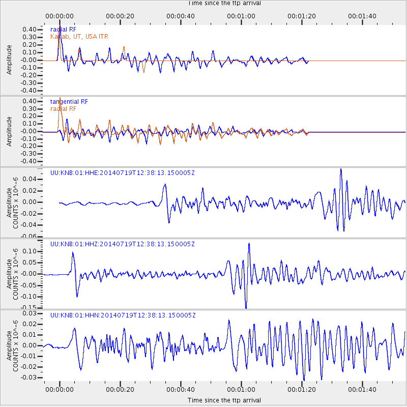
Signal To Noise
| Channel | StoN | STA | LTA |
| UU:KNB:01:HHZ:20140719T12:38:13.150005Z | 23.914688 | 3.1423323E-8 | 1.3139758E-9 |
| UU:KNB:01:HHN:20140719T12:38:13.150005Z | 3.5064578 | 4.9367745E-9 | 1.4079093E-9 |
| UU:KNB:01:HHE:20140719T12:38:13.150005Z | 6.988843 | 1.0633677E-8 | 1.5215218E-9 |
| Arrivals |
| Ps | 1.0 SECOND |
| PpPs | 4.1 SECOND |
| PsPs/PpSs | 5.1 SECOND |


