You are here: Home > Network List > UU - University of Utah Regional Network Stations List
> Station RDMU Red Mountain, UT, USA > Earthquake Result Viewer
RDMU Red Mountain, UT, USA - Earthquake Result Viewer

| Earthquake location: |
Tonga Islands |
| Earthquake latitude/longitude: |
-15.8/-174.4 |
| Earthquake time(UTC): |
2014/07/19 (200) 12:27:09 GMT |
| Earthquake Depth: |
220 km |
| Earthquake Magnitude: |
6.0 MWP |
| Earthquake Catalog/Contributor: |
NEIC PDE/NEIC COMCAT |
|
| Network: |
UU University of Utah Regional Network |
| Station: |
RDMU Red Mountain, UT, USA |
| Lat/Lon: |
40.57 N/109.57 W |
| Elevation: |
2087 m |
|
| Distance: |
82.2 deg |
| Az: |
44.105 deg |
| Baz: |
241.59 deg |
| Ray Param: |
0.04654511 |
| Estimated Moho Depth: |
12.0 km |
| Estimated Crust Vp/Vs: |
2.04 |
| Assumed Crust Vp: |
6.207 km/s |
| Estimated Crust Vs: |
3.039 km/s |
| Estimated Crust Poisson's Ratio: |
0.34 |
|
| Radial Match: |
87.55574 % |
| Radial Bump: |
303 |
| Transverse Match: |
81.33639 % |
| Transverse Bump: |
400 |
| SOD ConfigId: |
751272 |
| Insert Time: |
2014-08-02 13:32:22.850 +0000 |
| GWidth: |
2.5 |
| Max Bumps: |
400 |
| Tol: |
0.001 |
|
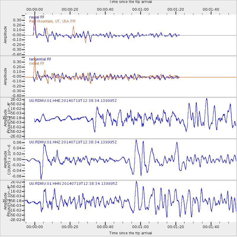
Signal To Noise
| Channel | StoN | STA | LTA |
| UU:RDMU:01:HHZ:20140719T12:38:34.139995Z | 10.898178 | 2.592254E-8 | 2.3786122E-9 |
| UU:RDMU:01:HHN:20140719T12:38:34.139995Z | 3.0618722 | 4.0607655E-9 | 1.3262361E-9 |
| UU:RDMU:01:HHE:20140719T12:38:34.139995Z | 3.0441854 | 5.4800506E-9 | 1.8001698E-9 |
| Arrivals |
| Ps | 2.1 SECOND |
| PpPs | 5.8 SECOND |
| PsPs/PpSs | 7.8 SECOND |


