You are here: Home > Network List > UW - Pacific Northwest Regional Seismic Network Stations List
> Station BRAN Beach Ranch, Enterprise, OR, USA > Earthquake Result Viewer
BRAN Beach Ranch, Enterprise, OR, USA - Earthquake Result Viewer
| Earthquake location: |
Tonga Islands |
| Earthquake latitude/longitude: |
-15.8/-174.4 |
| Earthquake time(UTC): |
2014/07/19 (200) 12:27:09 GMT |
| Earthquake Depth: |
220 km |
| Earthquake Magnitude: |
6.0 MWP |
| Earthquake Catalog/Contributor: |
NEIC PDE/NEIC COMCAT |
|
| Network: |
UW Pacific Northwest Regional Seismic Network |
| Station: |
BRAN Beach Ranch, Enterprise, OR, USA |
| Lat/Lon: |
45.97 N/117.23 W |
| Elevation: |
1136 m |
|
| Distance: |
80.2 deg |
| Az: |
36.492 deg |
| Baz: |
235.18 deg |
| Ray Param: |
0.047883075 |
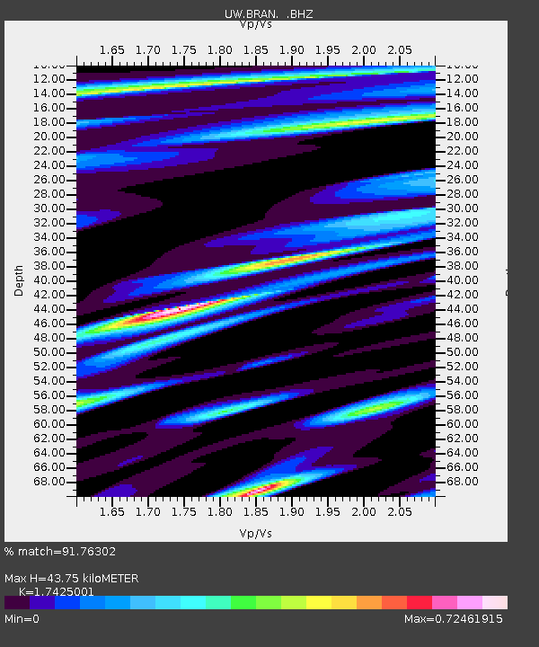
| Estimated Moho Depth: |
43.75 km |
| Estimated Crust Vp/Vs: |
1.74 |
| Assumed Crust Vp: |
6.571 km/s |
| Estimated Crust Vs: |
3.771 km/s |
| Estimated Crust Poisson's Ratio: |
0.25 |
|
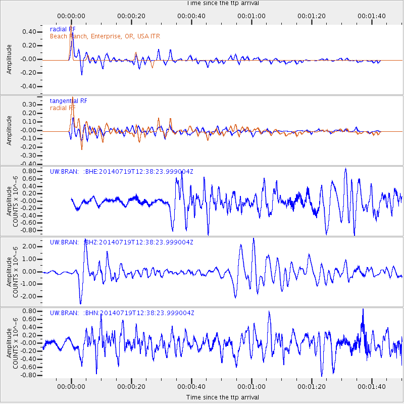
| Radial Match: |
91.76302 % |
| Radial Bump: |
400 |
| Transverse Match: |
74.28214 % |
| Transverse Bump: |
400 |
| SOD ConfigId: |
751272 |
| Insert Time: |
2014-08-02 13:33:10.608 +0000 |
| GWidth: |
2.5 |
| Max Bumps: |
400 |
| Tol: |
0.001 |
|
Signal To Noise
| Channel | StoN | STA | LTA |
| UW:BRAN: :BHZ:20140719T12:38:23.999004Z | 16.228413 | 1.2104915E-6 | 7.459087E-8 |
| UW:BRAN: :BHN:20140719T12:38:23.999004Z | 3.4160638 | 2.1224079E-7 | 6.213022E-8 |
| UW:BRAN: :BHE:20140719T12:38:23.999004Z | 3.7103794 | 3.1329859E-7 | 8.4438426E-8 |
| Arrivals |
| Ps | 5.1 SECOND |
| PpPs | 18 SECOND |
| PsPs/PpSs | 23 SECOND |


