You are here: Home > Network List > UW - Pacific Northwest Regional Seismic Network Stations List
> Station FISH Seaside, OR, USA > Earthquake Result Viewer
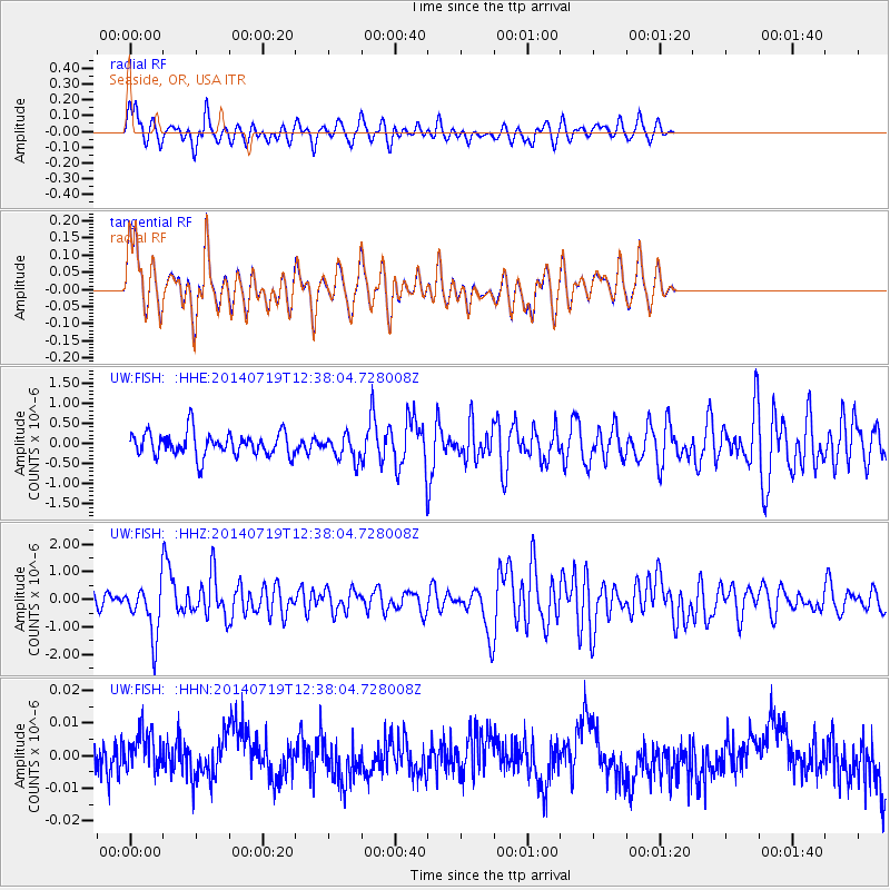
FISH Seaside, OR, USA - Earthquake Result Viewer
*The percent match for this event was below the threshold and hence no stack was calculated.
| Earthquake location: |
Tonga Islands |
| Earthquake latitude/longitude: |
-15.8/-174.4 |
| Earthquake time(UTC): |
2014/07/19 (200) 12:27:09 GMT |
| Earthquake Depth: |
220 km |
| Earthquake Magnitude: |
6.0 MWP |
| Earthquake Catalog/Contributor: |
NEIC PDE/NEIC COMCAT |
|
| Network: |
UW Pacific Northwest Regional Seismic Network |
| Station: |
FISH Seaside, OR, USA |
| Lat/Lon: |
45.93 N/123.56 W |
| Elevation: |
325 m |
|
| Distance: |
76.7 deg |
| Az: |
33.792 deg |
| Baz: |
230.101 deg |
| Ray Param: |
$rayparam |
*The percent match for this event was below the threshold and hence was not used in the summary stack. |
|
| Radial Match: |
67.52346 % |
| Radial Bump: |
400 |
| Transverse Match: |
67.6331 % |
| Transverse Bump: |
400 |
| SOD ConfigId: |
751272 |
| Insert Time: |
2014-08-02 13:33:28.446 +0000 |
| GWidth: |
2.5 |
| Max Bumps: |
400 |
| Tol: |
0.001 |
|
Signal To Noise
| Channel | StoN | STA | LTA |
| UW:FISH: :HHZ:20140719T12:38:04.728008Z | 4.7892427 | 9.2675384E-7 | 1.9350738E-7 |
| UW:FISH: :HHN:20140719T12:38:04.728008Z | 0.9816589 | 6.1602394E-9 | 6.2753367E-9 |
| UW:FISH: :HHE:20140719T12:38:04.728008Z | 1.0051445 | 2.9661703E-7 | 2.9509889E-7 |
| Arrivals |
| Ps | |
| PpPs | |
| PsPs/PpSs | |


