You are here: Home > Network List > WY - Yellowstone Wyoming Seismic Network Stations List
> Station YHH Holmes Hill, YNP, WY, USA > Earthquake Result Viewer
YHH Holmes Hill, YNP, WY, USA - Earthquake Result Viewer
| Earthquake location: |
Tonga Islands |
| Earthquake latitude/longitude: |
-15.8/-174.4 |
| Earthquake time(UTC): |
2014/07/19 (200) 12:27:09 GMT |
| Earthquake Depth: |
220 km |
| Earthquake Magnitude: |
6.0 MWP |
| Earthquake Catalog/Contributor: |
NEIC PDE/NEIC COMCAT |
|
| Network: |
WY Yellowstone Wyoming Seismic Network |
| Station: |
YHH Holmes Hill, YNP, WY, USA |
| Lat/Lon: |
44.79 N/110.85 W |
| Elevation: |
2717 m |
|
| Distance: |
83.4 deg |
| Az: |
39.929 deg |
| Baz: |
240.198 deg |
| Ray Param: |
0.04569249 |
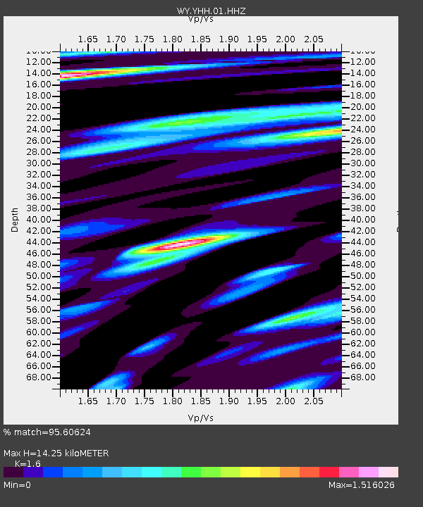
| Estimated Moho Depth: |
14.25 km |
| Estimated Crust Vp/Vs: |
1.60 |
| Assumed Crust Vp: |
6.35 km/s |
| Estimated Crust Vs: |
3.969 km/s |
| Estimated Crust Poisson's Ratio: |
0.18 |
|
| Radial Match: |
95.60624 % |
| Radial Bump: |
400 |
| Transverse Match: |
91.15364 % |
| Transverse Bump: |
358 |
| SOD ConfigId: |
751272 |
| Insert Time: |
2014-08-02 13:35:56.050 +0000 |
| GWidth: |
2.5 |
| Max Bumps: |
400 |
| Tol: |
0.001 |
|
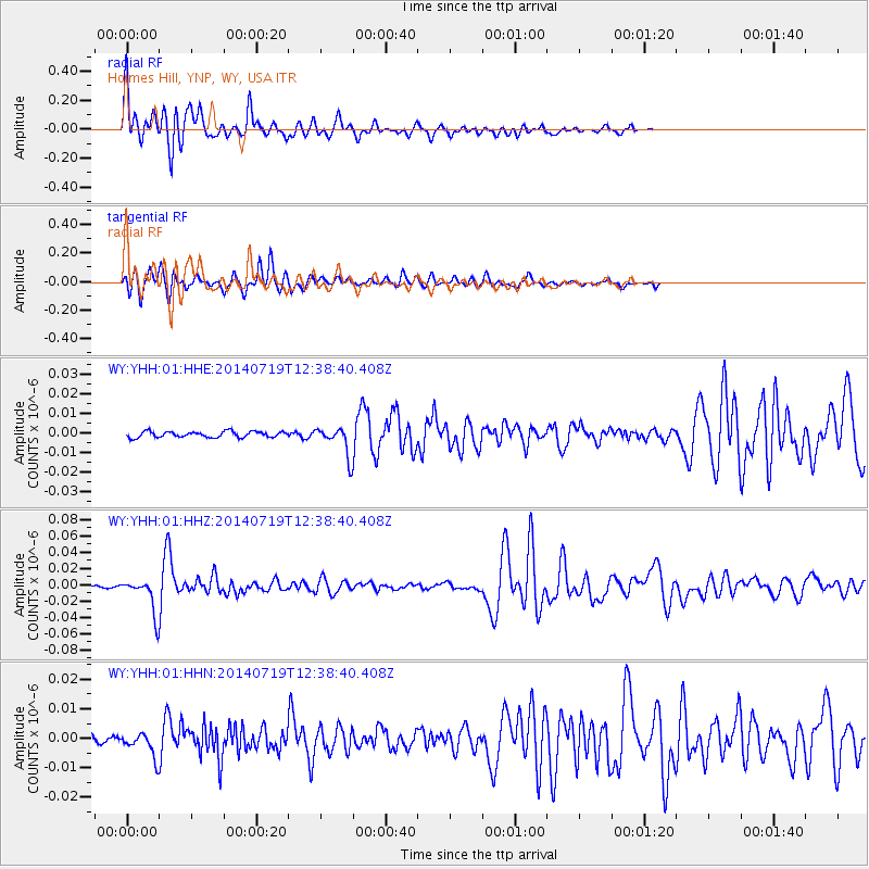
Signal To Noise
| Channel | StoN | STA | LTA |
| WY:YHH:01:HHZ:20140719T12:38:40.408Z | 16.010056 | 2.05196E-8 | 1.2816694E-9 |
| WY:YHH:01:HHN:20140719T12:38:40.408Z | 2.5420258 | 3.9418846E-9 | 1.5506864E-9 |
| WY:YHH:01:HHE:20140719T12:38:40.408Z | 4.840373 | 7.1561272E-9 | 1.4784248E-9 |
| Arrivals |
| Ps | 1.4 SECOND |
| PpPs | 5.7 SECOND |
| PsPs/PpSs | 7.1 SECOND |


