You are here: Home > Network List > YN10 - San Jacinto Fault Zone Stations List
> Station TR01 TR01 > Earthquake Result Viewer
TR01 TR01 - Earthquake Result Viewer
| Earthquake location: |
Tonga Islands |
| Earthquake latitude/longitude: |
-15.8/-174.4 |
| Earthquake time(UTC): |
2014/07/19 (200) 12:27:09 GMT |
| Earthquake Depth: |
220 km |
| Earthquake Magnitude: |
6.0 MWP |
| Earthquake Catalog/Contributor: |
NEIC PDE/NEIC COMCAT |
|
| Network: |
YN San Jacinto Fault Zone |
| Station: |
TR01 TR01 |
| Lat/Lon: |
33.42 N/116.41 W |
| Elevation: |
774 m |
|
| Distance: |
73.8 deg |
| Az: |
47.592 deg |
| Baz: |
238.205 deg |
| Ray Param: |
0.052140485 |
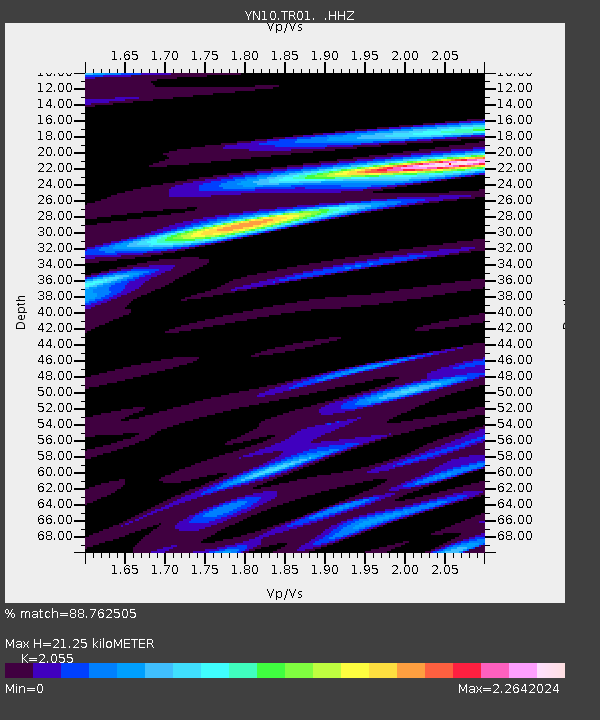
| Estimated Moho Depth: |
21.25 km |
| Estimated Crust Vp/Vs: |
2.06 |
| Assumed Crust Vp: |
6.264 km/s |
| Estimated Crust Vs: |
3.048 km/s |
| Estimated Crust Poisson's Ratio: |
0.34 |
|
| Radial Match: |
88.762505 % |
| Radial Bump: |
400 |
| Transverse Match: |
75.33925 % |
| Transverse Bump: |
400 |
| SOD ConfigId: |
751272 |
| Insert Time: |
2014-08-02 13:37:31.106 +0000 |
| GWidth: |
2.5 |
| Max Bumps: |
400 |
| Tol: |
0.001 |
|

Signal To Noise
| Channel | StoN | STA | LTA |
| YN:TR01: :HHZ:20140719T12:37:48.603984Z | 11.049393 | 1.0805012E-6 | 9.778829E-8 |
| YN:TR01: :HHN:20140719T12:37:48.603984Z | 1.7985889 | 2.9420437E-7 | 1.6357511E-7 |
| YN:TR01: :HHE:20140719T12:37:48.603984Z | 2.687484 | 3.8941528E-7 | 1.4489956E-7 |
| Arrivals |
| Ps | 3.7 SECOND |
| PpPs | 10 SECOND |
| PsPs/PpSs | 14 SECOND |


