You are here: Home > Network List > YN10 - San Jacinto Fault Zone Stations List
> Station TR02 TR02 > Earthquake Result Viewer
TR02 TR02 - Earthquake Result Viewer
| Earthquake location: |
Tonga Islands |
| Earthquake latitude/longitude: |
-15.8/-174.4 |
| Earthquake time(UTC): |
2014/07/19 (200) 12:27:09 GMT |
| Earthquake Depth: |
220 km |
| Earthquake Magnitude: |
6.0 MWP |
| Earthquake Catalog/Contributor: |
NEIC PDE/NEIC COMCAT |
|
| Network: |
YN San Jacinto Fault Zone |
| Station: |
TR02 TR02 |
| Lat/Lon: |
33.42 N/116.42 W |
| Elevation: |
770 m |
|
| Distance: |
73.8 deg |
| Az: |
47.595 deg |
| Baz: |
238.204 deg |
| Ray Param: |
0.052143645 |
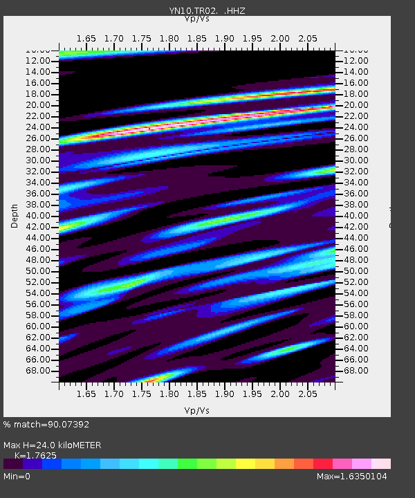
| Estimated Moho Depth: |
24.0 km |
| Estimated Crust Vp/Vs: |
1.76 |
| Assumed Crust Vp: |
6.264 km/s |
| Estimated Crust Vs: |
3.554 km/s |
| Estimated Crust Poisson's Ratio: |
0.26 |
|
| Radial Match: |
90.07392 % |
| Radial Bump: |
400 |
| Transverse Match: |
83.69616 % |
| Transverse Bump: |
400 |
| SOD ConfigId: |
751272 |
| Insert Time: |
2014-08-02 13:37:38.477 +0000 |
| GWidth: |
2.5 |
| Max Bumps: |
400 |
| Tol: |
0.001 |
|

Signal To Noise
| Channel | StoN | STA | LTA |
| YN:TR02: :HHZ:20140719T12:37:48.579021Z | 10.614564 | 1.0224442E-6 | 9.632465E-8 |
| YN:TR02: :HHN:20140719T12:37:48.579021Z | 2.8572881 | 3.233728E-7 | 1.1317473E-7 |
| YN:TR02: :HHE:20140719T12:37:48.579021Z | 1.5129645 | 2.8615827E-7 | 1.8913748E-7 |
| Arrivals |
| Ps | 3.0 SECOND |
| PpPs | 10 SECOND |
| PsPs/PpSs | 13 SECOND |


